For now we stress one valuable application, namely a study of the behavior of frontal passage. A meteogram is a perfect record of how everything changes as a front goes by. We can use this to predict what might happen when a front approaches us.
This study can be done with plots of past data or forecasted data. For now we use the latter from this website:
These are forecasts, based on the NAM model. To use these, go to that link, then click the region of interest such as SE US as shown below. We will use that data to investigate the passage of a cold front over Alice Town, in the Bahamas. The surface analysis map we use was valid at 18z on Mar 4, 2012.
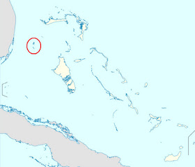
The index map and an expanded map shows where the station is located. On the next page we see a section of the OPC marine map below, above the Unified Analysis (UA) map at the same time. The UA map is clearer for some analysis, but we get winds near Alice Town better from the OPC map. As a side note this shows how the UA maps can supplement the ocean maps in some cases. They are available every 3hr, whereas the marine maps are only every 6 hours.
The meteogram forecast is shown below the map. Now the job is to study the data before and after the frontal passage to see how the various factors were expected to change. Look at the map first to make your predictions of what will happen, then look to the meteogram to see how this pans out.
wind speed ________/ _________
wind direction ________/ _________
pressure ________ /_________
air temp ________/ _________
visibility _________ /_________
Check the map first to get your prediction, then compare with what the meteogram says, and then check too the station reports on the map.
Meteograms are a great way to learn about forecasting and what to expect as certain systems pass over us. The hourly weather graphs mentioned above also show nicely when the air temp is expected to drop to the dew point, which is when fog will set in.
For mariners or weather watchers in the Pacific NW, you can access the very nice meteograms at any location of your choice at the UW Atmospheric Sciences Make your own meteograms. These are output from their WRF-GFS model runs which should be more accurate data in principle than corresponding ones from the link above because they take into account the terrain and texture of the surfaces and other local factors.
To study front passage and expected wind shifts (ie always a veer) check out our online course on Marine Weather. The books and software are also sold separately.


I have just scrolled through all of the topics of your blog. I am a professional mariner and holder of a 1st Mate's certificate and am very impressed by the sheer amount of information that you have presented here. As a previous commentor had said, and I will repeat - it is readily apparent that you are truly passionate about the subject of navigation. Being somewhat of a 'techno-dinosaur' (and very close to retirement - I loved working at sea), in fact, your notes on ENC / ECDIS, setting safety depths, alarms, etc., was quite informative.
ReplyDeleteKeep up the excellent work!
Gerry: Thanks for your kind words.
ReplyDelete