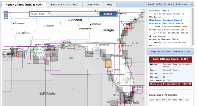
This should not be a surprise. NOAA told us they were Sunsetting Traditional Paper Charts back in 2019 and that they would all be gone by the end of 2024. After these charts are gone, we will rely on electronic navigational charts (ENC) and the new NOAA Custom Charts (NCC) that we design on our own using an online NOAA app and print on our own in a size and quality we choose.
This note is an alert that this is happening at an accelerated rate... plus we have a way now to know the status of our favorite charts. In item (1) of our starpath.com/getcharts resource, go to the paper chart index on the left and you will see something like shown below for the San Juan Islands area.
Notice a few things new. Several of the charts are now gray and their traditional names have been changed to be preceded by the letters "LE." This means "last edition." I have clicked one of them (it turns orange) to show its details on the right. Take notice of the text in red. This chart is no longer updated and will be removed on Oct 5, 2022—2 month and 13 days from today. The same with all of the gray ones.
These are not random, obscure charts. These are the main working charts for the San Juan Islands, and it is not just this area. The extent of cancelation is even higher on the Gulf and East Coasts.
All gray charts west of Alabama are schedule for cancellation same time as the West Coast (Oct 5, 2022). Those on the East Gulf Coast and on the SE Atlantic are scheduled for Jan 4, 2023—that is 5 months 14 days from today.
The Central Atlantic has a lot charts leaving on Nov 16, 2022, which is just 3 months and 25 days.
When these traditional charts are gone, there are two NOAA Print on Demand outlets that have announced on their websites that they are set up to print the new ENC versions of these same charts. In other words, they are considering making their own NCC that are the exact aspects, scales and sizes so you could just ask for the chart number.
But it is not clear if that is the best solution. The NCC app gives the chart designer a lot of freedom on what is included and what exact area is covered and at what scale. I think it will be best for mariners to learn how to use the NCC app to make their own decisions on what paper charts they want to replace the old ones.
Luckily, there is an easy place to go to learn to use the NCC app, namely the Starpath online
Course on Electronic Chart Navigation, which includes our unique textbook on the subject. We focus on the actual ENC usage, but do have an extended lesson on how to make the NCC along with practice exercises and individual support.
Needless to say, the goal of the
US National Charting Plan is not to navigate on these NCC, but rather to navigate on the ENC, which is what we teach. But NOAA knows that many mariners, if not most, do indeed want to have access to a paper chart at all times, just in case—and that is the main purpose of the NCC.
Beside NOAA doing away with the traditional paper charts in lieu of ENC and NCC made from them, the USCG is helping this transition along. They have just competed a call for comments on their
proposed new ruling that commercial vessels
must have on board a functional way (ECS or ECDIS) to use the official ENC. Third party charts that dominate the recreational echart world, do not count.
In short, we have arrived at the moment where we have gone from a time when the ENC were a legal alternative to paper charts to a time when ENC are the required means of navigation. We stand by to learn how this specific ruling evolves, and what all vessels will be covered, but it will indeed be enacted.
The side message to this note is this: knowing how to find these LE dates, if you want a copy of the last valid traditional paper chart, now is the time to order it. Right now you can still even get a PDF of it.
______________


When a chart is cancelled Office of Coast Survey is providing the last edition in pdf and jpg formats on the Historical Map & Chart Collection at https://historicalcharts.noaa.gov
ReplyDeleteOn that page, I find it easiest to locate charts by chart number. Enter the chart number in the box labelled "Chart" in the "Search Criteria" area below the map, then click Search.
In the search results, look for the edition labelled "last". If the chart is cancelled you will see links to the pdf and jpg downloads.
The Historical Map & Chart Collection has some really interesting charts going way back. It is well worth the time to browse around the site.
IMHO the boating public is losing an important resource with the discontinuation of raster charts. So far I am unconvinced that NCC is a good substitute for traditional raster charts. NOAA is still early in the development process so I am hopeful that future versions of NCC will be improved.
David: Thanks to you for all you have taught me through this blog!
Thanks for your valuable note and kind words. The NCC do have a ways to go, but I am optimistic that they can eventually be superior to the traditional paper charts.
ReplyDeletePlease note that as of July, 2023 55% of all NOAA paper charts have been discontinued, and we are assured by NOAA that they are on schedule—all will be replaced with ENC by the end of next year, if not earlier.
ReplyDelete