Sunday, November 30, 2014

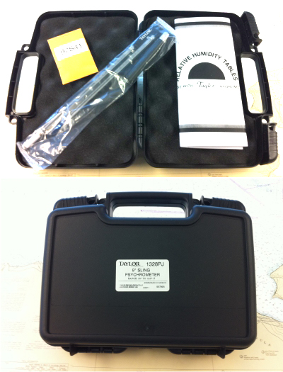
Taylor 1328PJ Sling Psychrometer — a Review
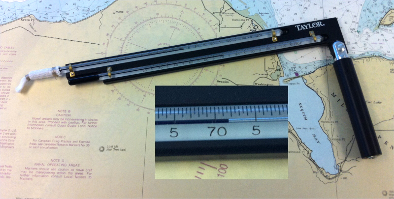
Relative humidity (RH) is a tricky measurement, primarily because it is so sensitive to the air temperature. One of the most basic measurements of RH is also one of the least expensive, namely a sling psychrometer. It has two identical thermometers one that remains dry (dry bulb) and the other covered by a clean cotton wick that is made wet with clean fresh water. Both are mounted on a swivel that can be swung about for the purpose of increasing the rate of evaporation of water on the wick.
Since the process of evaporation takes energy it cools the water, wick, and the thermometer inside it as the water evaporates; the more the evaporation, the more the cooling. But there is a limit, and that limit depends on the evaporation rate and that rate depends on the relative humidity of the air that is being evaporated into. Thus the suppression of the wet bulb thermometer temperature compared to that of the dry bulb thermometer is a measure of the relative humidity of the air at the dry bulb air temperature.
We have tested several of the these Taylor units. They are well made and a nice compromise in price, size, and accuracy. The list price is about $180 these days, but generally you can find them notably less... and I have seen then on eBay called new for well under $100.
Range 20°F to 120°F
9" Permacolor™ filled thermometers
Temperature accuracy ± 0.2°
Folding swivel handle
Hard plastic protective case (about a 12 " wide)
6 replacement wicks
 The instrument is used by wetting the clean
wick with distilled water, then swirling it around for about 30 seconds
or more (rather vigorously) and then reading the wet bulb and dry bulb temperatures. With these
values you can look in tables (included with the device) to learn the
dew point of the air and its relative humidity.
Or go to this link to find both RH and dew point from the two temperatures: www.starpath.com/calc. Dew point is of more interest to navigators as it tells us how far we are from fog, whereas RH is of more interest to human comfort and how other things like violins and cigars interact with the atmosphere. Also for optimum espresso you have to change your grind number by 1 or 2 with RH changes between say 40 and 70.

By plotting dew point and temperature as a function of time you can often predict when fog will form. Accurate sling psychrometers like these can also be used to calibrate hygrometers that read the relative humidity directly on a dial.
Here is a quick test of 4 Taylor units showing the dependability of the thermometers. The wet and dry bulb temperatures should be identical for all units on a given time when sitting side-by-side at rest, out of breezes, and on a uniform temperature base. Also keep in mind looking at the dial, that tenths of a degree must be estimated. These were read using a magnifying glass, being careful to avoid parallax errors, and being careful to not get so close to the thermometer that radiant heat from your own body does not change the reading, which is a real concern, because the result is sensitive to tenths of a degree. Clearly they are all well within the specs given by Taylor. This is a crucial condition, because the accuracy of the humidity and dew point results are a direct computation from the temperature data. (Unit 4 was sold on Day 2.)
 We only have these data at this temperature, but from this the instruments look good, and we have used our in-house model for several years.
A few related, random notes:
(1) There are devices like this that have reservoirs for the wick water and fans that blow on the dial (ie do not have to swing them) and some have even more accurate thermometers. These are called Assmann aspiration psychrometers. Good ones cost $1000 to $1500. These units can get RH to about 2%.
(2) RH can be measured directly, either electronically or mechanically (based on the fact that how much human hair stretches depends on the RH).
(3) Electronic units that read RH directly and cost less than $100 or so, probably do not work.... ie compare 5 or 6 side by side and they will differ by 20 to 40%. Even ones that cost $1,000 have to be calibrated every year or so.
(3) Hair hygrometers can be human hair (works all temperatures) or synthetic hair, works above freezing. The Fischer Precision Instrument Company that is famous for high quality barometers receives the same high esteem worldwide for their hair hygrometers. Synthetic hair takes less maintenance. Always get a matching thermometer to sit beside it as you must know both numbers to do anything with the results. ie, to say the RH is 40% does not tell you much about the conditions of your atmosphere without knowing what temperature that was. Fisher hair hygrometers (model 122.01) cost about $60 and yield about 3-5% accuracy... all such instruments must be calibrated at some point. Matching thermometer (model 117.01) costs about $40.
(5) I must also add that we have not tested less expensive sling psychrometers. It could be that some that cost much less will also do the job. They key issue is are the thermometers identical and how accurate can you read them. In principle you could make your own from two thermometers and just blow a fan on them. We have done that with our Taylor and that works fine.... if not better than slinging it around. The wicks are easy to find online. You might call that one a half-Assmann model.
In short, a device like the Taylor model above is a good solution to many needs for accurate RH... or as a way to calibrate a good hair hygrometer.
Since the process of evaporation takes energy it cools the water, wick, and the thermometer inside it as the water evaporates; the more the evaporation, the more the cooling. But there is a limit, and that limit depends on the evaporation rate and that rate depends on the relative humidity of the air that is being evaporated into. Thus the suppression of the wet bulb thermometer temperature compared to that of the dry bulb thermometer is a measure of the relative humidity of the air at the dry bulb air temperature.
We have tested several of the these Taylor units. They are well made and a nice compromise in price, size, and accuracy. The list price is about $180 these days, but generally you can find them notably less... and I have seen then on eBay called new for well under $100.
Range 20°F to 120°F
9" Permacolor™ filled thermometers
Temperature accuracy ± 0.2°
Folding swivel handle
Hard plastic protective case (about a 12 " wide)
6 replacement wicks
By plotting dew point and temperature as a function of time you can often predict when fog will form. Accurate sling psychrometers like these can also be used to calibrate hygrometers that read the relative humidity directly on a dial.
Here is a quick test of 4 Taylor units showing the dependability of the thermometers. The wet and dry bulb temperatures should be identical for all units on a given time when sitting side-by-side at rest, out of breezes, and on a uniform temperature base. Also keep in mind looking at the dial, that tenths of a degree must be estimated. These were read using a magnifying glass, being careful to avoid parallax errors, and being careful to not get so close to the thermometer that radiant heat from your own body does not change the reading, which is a real concern, because the result is sensitive to tenths of a degree. Clearly they are all well within the specs given by Taylor. This is a crucial condition, because the accuracy of the humidity and dew point results are a direct computation from the temperature data. (Unit 4 was sold on Day 2.)

A few related, random notes:
(1) There are devices like this that have reservoirs for the wick water and fans that blow on the dial (ie do not have to swing them) and some have even more accurate thermometers. These are called Assmann aspiration psychrometers. Good ones cost $1000 to $1500. These units can get RH to about 2%.
(2) RH can be measured directly, either electronically or mechanically (based on the fact that how much human hair stretches depends on the RH).
(3) Electronic units that read RH directly and cost less than $100 or so, probably do not work.... ie compare 5 or 6 side by side and they will differ by 20 to 40%. Even ones that cost $1,000 have to be calibrated every year or so.
(3) Hair hygrometers can be human hair (works all temperatures) or synthetic hair, works above freezing. The Fischer Precision Instrument Company that is famous for high quality barometers receives the same high esteem worldwide for their hair hygrometers. Synthetic hair takes less maintenance. Always get a matching thermometer to sit beside it as you must know both numbers to do anything with the results. ie, to say the RH is 40% does not tell you much about the conditions of your atmosphere without knowing what temperature that was. Fisher hair hygrometers (model 122.01) cost about $60 and yield about 3-5% accuracy... all such instruments must be calibrated at some point. Matching thermometer (model 117.01) costs about $40.
(5) I must also add that we have not tested less expensive sling psychrometers. It could be that some that cost much less will also do the job. They key issue is are the thermometers identical and how accurate can you read them. In principle you could make your own from two thermometers and just blow a fan on them. We have done that with our Taylor and that works fine.... if not better than slinging it around. The wicks are easy to find online. You might call that one a half-Assmann model.
In short, a device like the Taylor model above is a good solution to many needs for accurate RH... or as a way to calibrate a good hair hygrometer.
Friday, November 7, 2014
Barometer for Wind Warning
There are numerous tactical uses of barometric pressure for safe efficient navigation, but here we take a quick look at just the basic one of using the barometer to anticipate strong winds.
In the picture below we see a classic case of wind rising with a pressure drop. We show this on the very nice combined display of wind and pressure shown on the NDBC websites, in this case for West Point Lighthouse (WPOW1), which is 1.6 nmi to the SW of Starpath HQ.
We see wind going from 5 kts to 32 kts in 9h... and in the first 6h of that it only went up to 15 kt, so really this is 15 to 32 in about 3h. This is something we would like to be prepared for as soon as possible. That 6h of watching the wind go from 5 to 15 is all wasted when we do not have a good barometer that could warn us that this wind increase could keep going on.
But even with a good barometer we still need a guideline to interpret what we observe. Our guideline is "4-5-6," meaning a drop of 4 or 5 mb in 6h is the sign to pay attention. This implies an average tendency (change in last 3h) of -2.0 or more.
In this example, we see a drop from 1025 at 12z on 5th to 1008 at 15z on the 6th, or 17 mb in 28h = 0.68 mb/h = 2.0 mb/3h. So the average drop rate in this example is plenty for a good warning, but once it starts down at this rate we still have to see this for 6 hours before the flag goes up.
Shown below the NDBC data, we have plotted the pressure tendency measured with a high precision NIST-traceable barometer here at Starpath. The scale on the left is pressure change in mb over the previous 3h. Looking above that to the pressure data, we see a drop from Point A (where the tendency first crossed 0.0) to Point B, marking 4 mb drop. This has dropped enough to keep an eye on, but not enough to conclusively trigger our 4-5-6 guideline because this took about 9h. After this point, however, you see an average tendency that is close enough to the 2.0 we need for a solid warning.
In other words, by the time of Point B, we should be fairly warned of strong wind potential. Thus we have (from B to C) about 18h warning that the wind we have watched increase to 15 is likely to increase notably more. Once we get to a tendency near 3.0 for a couple reports, we are beyond the forecasting zone; the strong wind is likely either imminent or present.
Starpath wind warning arrows
To help mariners take advantage of the accurate pressure measurements, we show below the pressure trend arrow conventions we recommend to all barometer mananufacturers. These offer a quick graphic view of the trend, which are scaled to match our strong wind warning guideline (4-5-6). The definitions are shown below.

With these definitions, keeping in mind our 4-5-6 guideline, we can make a shorter summary.

These arrows should be updated continuously on the dial face after the unit has been running for 1h, and with these we can anticipate the drop over the next 3h based on a projection of what we learned over the past 1h.
Note that the actual pressure tendency value that should be recorded with each pressure record is rigorously defined by the WMO and NWS as the pressure difference between now and 3h ago, so this value cannot be deduced until a barometer has been running for 3h or more.
The drawing below shows how these arrows would have shown up as the pressure dropped.
 Notice that the arrows would change during the short periods when the pressure flattened off during the drop, but the Fast Drop indicating real warning would dominate in this pattern.
Another point to stress is the pressure warning guideline assumes the wind is starting from light air. When the ambient wind is over 15 kt or so, as in the case to the left of this time period (3 days earlier) the guideline is not useful. In the open ocean, when the wind is above 15 to 20 kts to begin with, a rise in pressure often brings with it an increase of wind—most famously in the "sting of the scorpion's tail," which is the poetic description of a back bent occlusion. We see this behavior in the left-hand data for completely different reasons, but we are on inland waters here, effectively between two mountain ranges, so any standard pressure-wind forecasting can vary notably. Our guidelines were developed for the open ocean, but they are nevertheless a good guideline anywhere. As it turns out, the behavior seen here for this larger pressure drop is a fairly good example of what we might experience at sea.
Starpath data compared to NDBC data
In the pictures below we compare what we measured at Starpath compared to what we downloaded from the WPOW1 website. That instrument is located about 0.5 nmi form here. The agreement is very good. We actually have much more data in finer steps stored in our barometers, since we can only get data hourly from the website. Thus even with Internet access to this excellent data from the NDBC websites around the country, we still gain more resolution and earlier warning if you have your own precision instrument in hand.
In a later article I will discuss how precision barometers —even those in your phone — can be used underway for sailboat racing or cruising to predict wind changes on inland waterways. Then the precision and fine steps stored are especially valuable.

The red curve is from the Starpath calibration standard barometer. The blue from WPOW1. It has been randomly offset to show the comparison. Our instruments are located 5.8 mb above sea level. We see every small variation reproduced, which shows that such fine structure is indeed being created by subtle changes in the atmosphere, that at least cover a 1.6 mi radius, as that is the separation of the two instruments shown above.
We see even more interesting agreement on the tendency measurements at both locations. Again the red data is from an in house barometer; the blue from WPOW1.

In this case the elevation difference does not matter. Both instruments are just measureing how much the pressure has changed and their different elevations do not enter in. Here the scales and measured values are identical. Recording and plotting the tendency is valuable to ships who must report the pressure tendency with their regular weather reports back to the NWS. The detailed agreement and reproduced structure of the plot shows that this is indeed a measurable information that can help with forecasting and analysis.
In the picture below we see a classic case of wind rising with a pressure drop. We show this on the very nice combined display of wind and pressure shown on the NDBC websites, in this case for West Point Lighthouse (WPOW1), which is 1.6 nmi to the SW of Starpath HQ.
 |
| Top is wind and pressure from NDBC reports for West Point Lighthouse in Seattle. Bottom is the pressure tendency (mb change over the past 3h) measured with a precision barometer at Starpath HQ, 1.6 nmi away. |
But even with a good barometer we still need a guideline to interpret what we observe. Our guideline is "4-5-6," meaning a drop of 4 or 5 mb in 6h is the sign to pay attention. This implies an average tendency (change in last 3h) of -2.0 or more.
In this example, we see a drop from 1025 at 12z on 5th to 1008 at 15z on the 6th, or 17 mb in 28h = 0.68 mb/h = 2.0 mb/3h. So the average drop rate in this example is plenty for a good warning, but once it starts down at this rate we still have to see this for 6 hours before the flag goes up.
Shown below the NDBC data, we have plotted the pressure tendency measured with a high precision NIST-traceable barometer here at Starpath. The scale on the left is pressure change in mb over the previous 3h. Looking above that to the pressure data, we see a drop from Point A (where the tendency first crossed 0.0) to Point B, marking 4 mb drop. This has dropped enough to keep an eye on, but not enough to conclusively trigger our 4-5-6 guideline because this took about 9h. After this point, however, you see an average tendency that is close enough to the 2.0 we need for a solid warning.
In other words, by the time of Point B, we should be fairly warned of strong wind potential. Thus we have (from B to C) about 18h warning that the wind we have watched increase to 15 is likely to increase notably more. Once we get to a tendency near 3.0 for a couple reports, we are beyond the forecasting zone; the strong wind is likely either imminent or present.
Starpath wind warning arrows
To help mariners take advantage of the accurate pressure measurements, we show below the pressure trend arrow conventions we recommend to all barometer mananufacturers. These offer a quick graphic view of the trend, which are scaled to match our strong wind warning guideline (4-5-6). The definitions are shown below.
With these definitions, keeping in mind our 4-5-6 guideline, we can make a shorter summary.
These arrows should be updated continuously on the dial face after the unit has been running for 1h, and with these we can anticipate the drop over the next 3h based on a projection of what we learned over the past 1h.
Note that the actual pressure tendency value that should be recorded with each pressure record is rigorously defined by the WMO and NWS as the pressure difference between now and 3h ago, so this value cannot be deduced until a barometer has been running for 3h or more.
The drawing below shows how these arrows would have shown up as the pressure dropped.
Another point to stress is the pressure warning guideline assumes the wind is starting from light air. When the ambient wind is over 15 kt or so, as in the case to the left of this time period (3 days earlier) the guideline is not useful. In the open ocean, when the wind is above 15 to 20 kts to begin with, a rise in pressure often brings with it an increase of wind—most famously in the "sting of the scorpion's tail," which is the poetic description of a back bent occlusion. We see this behavior in the left-hand data for completely different reasons, but we are on inland waters here, effectively between two mountain ranges, so any standard pressure-wind forecasting can vary notably. Our guidelines were developed for the open ocean, but they are nevertheless a good guideline anywhere. As it turns out, the behavior seen here for this larger pressure drop is a fairly good example of what we might experience at sea.
Starpath data compared to NDBC data
In the pictures below we compare what we measured at Starpath compared to what we downloaded from the WPOW1 website. That instrument is located about 0.5 nmi form here. The agreement is very good. We actually have much more data in finer steps stored in our barometers, since we can only get data hourly from the website. Thus even with Internet access to this excellent data from the NDBC websites around the country, we still gain more resolution and earlier warning if you have your own precision instrument in hand.
In a later article I will discuss how precision barometers —even those in your phone — can be used underway for sailboat racing or cruising to predict wind changes on inland waterways. Then the precision and fine steps stored are especially valuable.
The red curve is from the Starpath calibration standard barometer. The blue from WPOW1. It has been randomly offset to show the comparison. Our instruments are located 5.8 mb above sea level. We see every small variation reproduced, which shows that such fine structure is indeed being created by subtle changes in the atmosphere, that at least cover a 1.6 mi radius, as that is the separation of the two instruments shown above.
We see even more interesting agreement on the tendency measurements at both locations. Again the red data is from an in house barometer; the blue from WPOW1.
In this case the elevation difference does not matter. Both instruments are just measureing how much the pressure has changed and their different elevations do not enter in. Here the scales and measured values are identical. Recording and plotting the tendency is valuable to ships who must report the pressure tendency with their regular weather reports back to the NWS. The detailed agreement and reproduced structure of the plot shows that this is indeed a measurable information that can help with forecasting and analysis.
Wednesday, September 3, 2014
Barometric Pressure During Squall Passage
Last year we posted a note here about an unexpected small rise in barometric pressure as a severe squall passed over a boat in the Caribbean (Local Pressure as a Squall Goes By). The article served two purposes, it documented that unexpected behavior and in doing so demonstrated the value of a having high quality precision barometer on board.Today, we get to carry on with that story, but with more data.
It started with a bike ride home from work, with just enough drizzle to put on rain pants. Ten minutes later however, the wind was at least 25 kts, gusting to 30, with rain heavy enough to reduce visibility to about 200 yards for a short time... not to mention an excellent test of good rain gear. This was an honest to goodness tropical squall, which I have seen many times underway... actually it was not at all a "tropical squall;" it just behaved like one. See Cliff Mass explanation of the system.
After dinner and much banter about the unusual likelihood of such a squall here in Seattle, I happen to notice the trace on an accurate barometer I have at home. Screen captures are shown below.
Thus we see that at about 1813 the pressure rose by about 0.8 mb above its trend over a period of 10 to 15 min. This instrument was roughly 25 ft above sea level, in a room with open windows, about a mile or two from the West Point Lighthouse (WPOW1), which recorded hourly (MSL) pressures of 1009.0 and 1009.7 at 1800 and 1900 PDT.
The new data here is some documentation of the squall as it also passed over the Atmospheric Sciences Building at UW, which has several fine instruments on the roof, as well as a precision barograph inside the building.
In the earlier note, linked above, we speculated that maybe there was some brief pressurization of the cabin on the boat where the barometer was located, but now there is clear question about that interpretation. Namely the environment of this instrument was rather different from the boat, and also we now have the UW data (below), from an entirely different environment.
They see the same bump about 5 min later, and about half the intensity, rising about 0.4 mb. For what it might be worth, my guess is the squall was less severe when it got to UW, which is about 5 mi east of here. I say this because we have the data (below) from their measurements, and I was right in the middle of this one, on a bike, and have some experience in the observations.
But they did indeed have a lot of rain, but this is much harder to gauge by eye to make comparisons. I would guess what we had here for a brief time was violent rain.
So in conclusion, we have clear proof of a squall and some estimate of its severity (there is likely other data on this as it was an unusual event) and we have two independent measurements of the pressure bump, in rather different measurement environments.
Now we just have to figure out what caused this... though there is no doubt that with a good barometer you learn things you would not otherwise. For example, we can see very nicely on my home barometer the local pressure variations that lead to the sea breeze in Puget Sound on a warm clear day. Later I will write up how racing sailors can use this information to predict the wind while underway in a race on Puget Sound.
PS... it is a bit difficult to tell what took place at West Point Lighthouse because they only record data hourly... but there was definitely some larger scale system in place over the region, which we will have to look up. The Lighthouse data is shown below, with the corresponding pressure trace from my barometer.
__________________
Follow up from the next day, Wed Sept 3.
At the office we have several accurate barometers that store data, so I checked one to see if we still had detail enough to see the bump, and sure enough we see this just fine, as shown below.

This illustrates three points. One is we have still another completely different environment of the instrument during the measurement, so this seems to imply this might not be the factor.
And second, it seems we may have a real meteorological effect here to understand. We need to rig up our Gill Pressure port, and have this set up outside for the next squall to remove all such influences.... unfortunately (in this regard) Seattle has only some 4 or 5 squall days per year.
The other important point to observe is the great value—for research and careful foreacsting—of a barometer that can store digital data and then transfer it to a computer for archiving or further analysis. There are several units on the market that will do this, and some phone barometers can export the data as well. The barometer in the Kestrel 550 hand held wind meter, for example will even blue tooth high precision barometer data to a phone or tablet. This is a rapidly changing technology and high precision barometric pressure is now readily available.
In the above example, 24 h ago, this bump was just barely visible on the crude display screen of the instrument itself, but we could just connect it to a computer with a USB cable, export the data to a spread sheet and plot it. The whole process took just a few minutes.
It started with a bike ride home from work, with just enough drizzle to put on rain pants. Ten minutes later however, the wind was at least 25 kts, gusting to 30, with rain heavy enough to reduce visibility to about 200 yards for a short time... not to mention an excellent test of good rain gear. This was an honest to goodness tropical squall, which I have seen many times underway... actually it was not at all a "tropical squall;" it just behaved like one. See Cliff Mass explanation of the system.
After dinner and much banter about the unusual likelihood of such a squall here in Seattle, I happen to notice the trace on an accurate barometer I have at home. Screen captures are shown below.
 |
| Shown on a 6 hr trace, the bump is at about -2.5h |
 |
| Same data, zoomed to past 3 hr, but captured at a different time. |
We can look at real times since this barometer has an accurate clock.
 | ||||||
| The cursor is the close dotted line showing the pressure was 1008.4 at 1802 or so, just before the event. |
 | |
| The peak pressure of 1009.2 occurred at 1813 (PDT). |
 |
| The pressure continued its pre-bump rise by about 1825. |
The new data here is some documentation of the squall as it also passed over the Atmospheric Sciences Building at UW, which has several fine instruments on the roof, as well as a precision barograph inside the building.
In the earlier note, linked above, we speculated that maybe there was some brief pressurization of the cabin on the boat where the barometer was located, but now there is clear question about that interpretation. Namely the environment of this instrument was rather different from the boat, and also we now have the UW data (below), from an entirely different environment.
 | ||
| High precision barograph at UW Atmospheric Sciences. |
 | ||
| Unless their meter is blocked on some level, I know for certain we had much stronger winds at our location. |
 |
| They recorded about a quarter inch of rain in a few minutes. |
 | ||
| This record of rain gauge bucket tips shows the downpour even more clearly. |
 |
| And as you would expect with a big squall, there was a fast and notable air temperature drop. |
 |
| Likewise as we would expect in a fast moving squall, the wind direction was all over the place. |
So in conclusion, we have clear proof of a squall and some estimate of its severity (there is likely other data on this as it was an unusual event) and we have two independent measurements of the pressure bump, in rather different measurement environments.
Now we just have to figure out what caused this... though there is no doubt that with a good barometer you learn things you would not otherwise. For example, we can see very nicely on my home barometer the local pressure variations that lead to the sea breeze in Puget Sound on a warm clear day. Later I will write up how racing sailors can use this information to predict the wind while underway in a race on Puget Sound.
PS... it is a bit difficult to tell what took place at West Point Lighthouse because they only record data hourly... but there was definitely some larger scale system in place over the region, which we will have to look up. The Lighthouse data is shown below, with the corresponding pressure trace from my barometer.
 |
| Wind and pressure at West Point. Recall wind in kts is about 2 x wind in m/s. Notice that they had more wind here than at UW, and I would guess somewhat less then I experienced for a short period. |
 |
| This is the corresponding pressure trace from my home barometer. We clearly cannot see the details discussed above on this scale. |
Follow up from the next day, Wed Sept 3.
At the office we have several accurate barometers that store data, so I checked one to see if we still had detail enough to see the bump, and sure enough we see this just fine, as shown below.

And second, it seems we may have a real meteorological effect here to understand. We need to rig up our Gill Pressure port, and have this set up outside for the next squall to remove all such influences.... unfortunately (in this regard) Seattle has only some 4 or 5 squall days per year.
The other important point to observe is the great value—for research and careful foreacsting—of a barometer that can store digital data and then transfer it to a computer for archiving or further analysis. There are several units on the market that will do this, and some phone barometers can export the data as well. The barometer in the Kestrel 550 hand held wind meter, for example will even blue tooth high precision barometer data to a phone or tablet. This is a rapidly changing technology and high precision barometric pressure is now readily available.
In the above example, 24 h ago, this bump was just barely visible on the crude display screen of the instrument itself, but we could just connect it to a computer with a USB cable, export the data to a spread sheet and plot it. The whole process took just a few minutes.
Subscribe to:
Posts (Atom)