Thursday, January 31, 2019

Countercurrent Crossing Nav Problem Solutions

In an earlier note we posted a navigation problem asking for fastest way to row across the Pacific countercurrent, from 300 nmi off. The current is 1 kt flowing due east, over a 200 nmi span. The hypothetical rower can go 2.0 kts in any direction. The rhumb line route (RL) to the finish at Cairns, AU is 240T. We assume—not very realistically—that conditions on either side of the current are about the same and that we could indeed achieve a speed made good (SMG) of 2.0 kts in any direction outside of the current.

Please note:  this rowboat exercise is unique, but the problem itself is realistic and standard. Imagine, for example, that we change to sailboat, and consider the wind calm over the current (often in the doldrums) with a motoring speed of 6 kts, and then we put NE and SE trades on either side of the current belt and set sailing speeds to match the vessel.  The same types of current reckoning would still have to be carried out.

The challenge here is to find the best method to cross assuming the only goal was to get to the finish line in the shortest time. There are often other factors in practical navigation situations.  Also to be a bit more realistic, we have to consider that anywhere on the line that is equal distance from Cairns is a valid answer.  In other words, the finish line is not a point, but indeed a line.

The geometry is shown below, with the solution for no current. Rowing straight across along the RL.


With no current, we would stay on the RL and cross in about 350 h from 300 nmi off (14 days 14 hr). You can figure the length of the RL in current (400 nmi) from plotting, or by noting it is a side of a 30º right triangle that has sides 1:2:sqrt(3). The bottom side would then be 173 nmi.

We now look at various choices on how to cross, in no particular order. Later we come back to ask if there is a guiding philosophy that might lead us to the best solution directly.  Also for now we just look at the routes and the answers. I will add a video to this that explains the solutions and how to obtain them both graphically and numerically... and the really easy way, pull out the StarPilot that calculates all these solutions directly.

Also before getting into any details, I want to stress that all of the geometry and vector problems can be solved directly by plotting on a chart or with the use of a charting program, such as OpenCPN, which is a free product. Although we illustrate the math solutions, you can indeed solve any one of these with simple plotting on a scaled sheet of paper. 

Rose Point Coastal Explorer is a convenient echart program for this operation, primarily because of the way it labels the lines, and because it lets you draw a range and bearing line and then move it as you would with parallel rulers—a very convenient feature.  Below is a sample of this.


Sample plot from Coastal Explorer.  The current band is marked by two bearing lines, 200 nmi apart, and the rest of the solution is a combination of route lines and bearing lines.

 In the following approach we just steer the RL till we hit the current and then keep on steering that course knowing we are going to get set and then keep on that heading when we emerge from the current and stop the clock when we are equal distance to Cairns. The fact that we are now a bit south of where we were without current does not matter as it is the same distance to Cairns.  It is not part of this analysis, but we could be better off a bit south.  In any event, we get our first current crossing time, which is 436.4 hr.


Next we look at the crossing that drives down the RL till we hit the current, then we point into the current by the calculated angle that will keep us on our RL track. In other words, we can make good 2.0 and we ask how much do we have to point into a 1-kt current flowing toward 090 in order to achieve a CMG of 240. And then, when doing that, what will be our SMG as we cross?

These are standard navigation questions, which I will answer in the video. The related sketches are shown here, but only discussed there.


This turns out to be a terrible choice for crossing this current.  The total time is 523.8 hr. We already know one better way, and we will keep looking.  Again, refer to the forthcoming video for a review of the current solutions.

With that result in mind, we might try crossing the current in the fastest way by heading due south across it when we hit it. Then back on the RL to the finish line.  That solution is shown below. We beat crabbing across by a lot, but not as good as driving across on the RL heading.


Another approach might be head up stream enough that when we get set back crossing we end up where we want to be.  This is loosely called kayaker, as I recall using this method in a kayak when i did not want to compute things underway.  We know the set will be 100 nmi, but we still have some geometry to solve to know what the right heading is to get there and the distance that is (772 nmi). Again easily solved by plotting and we cover the trig in the video.


This method does seem a bit extreme and indeed it does not offer a competitive  time (461 hr).  But it does bring to mind a compromise which is a combination of previous attempts. Namely We head up stream till we are above where the RL exits the current band, then we crab due south the RL. 

Unless I have made some mistakes here, or have simply not found the best approach yet, this solution shown below seems to be the best generic solution, with a total time of 427.6 hr.  Heading farther west is likely wrong considering previous solutions, but there could be some intermediate point (say 150 nmi up stream instead of 346.4) that could be faster still.  Note, too, that even if the target were the point where the RL exits the current  band, rather than anywhere on the finish line, this would still be the best solution.


We see quite a range of solutions, which brings us back to the question of are there guiding principles that might tell us the answer to such questions. It can be set up mathematically and the minimum solved for. But it would be more rewarding to think of a guiding principle that points us to the right solution.  

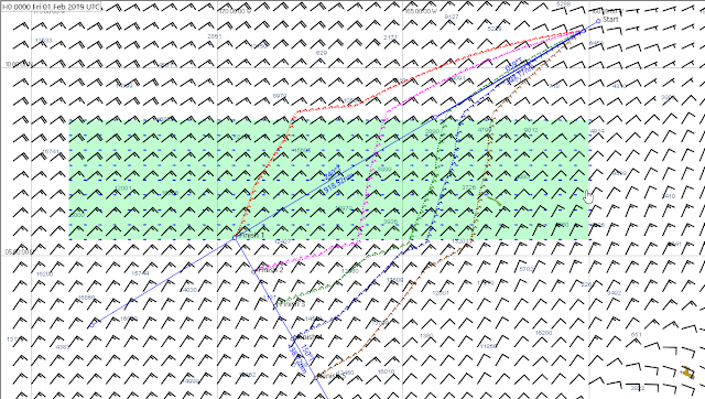
The popular routing program Expedition can in principle solve this, though it is not designed for this type of navigation.  Below is an attempt to do this routing, using a unique feature of Expedition that lets us build a custom current field in GRIB format.  Then I made a polar diagram that has boat speed of 2 kts regardless of wind speed or direction, and executed the route to several places along the finish line.


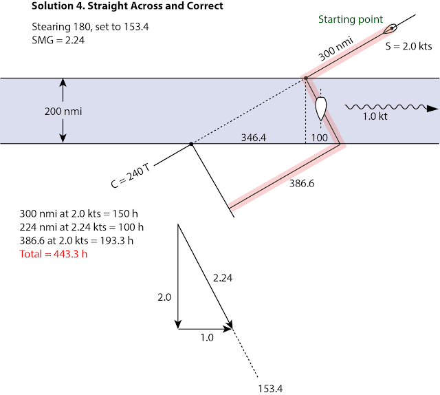
The routes are all within 10 hr or so, but the clear winner is the green one. Namely, row up to the current edge along the RL, and then crab across.  We are still trying to understand why it chose the crab angle it did—or implies it did—but this motivated us to try something similar; RL then crab due south across the current, and then back to RL to the finish line.  That is shown below.


and sure enough that is the fastest solution so far—and indeed a simple concept.  We are still standing by for some feedback and checks on our solutions. However, we are homing in on a philosophy, namely follow the RL and take the most direct path across the current.

Crabbing across the current, which is pretty much the only technique discussed in standard textbooks, is likely the slowest solution in all cases.  It should probably be reserved for navigating dangerous waters where you must stay on a particular track for safety sake.  We will follow up on this with some realistic current crossings on inland waters to see how far we can go with this idea.


Sunday, January 27, 2019

Tracking Jacob Adoram: An Exercise in Wind, Waves, and Currents

Jacob Adoram is rowing his custom vessel Emerson from Neah Bay, WA non-stop to Cairns, AU. He departed July 7, 2018 and now (Jan 26, 2019) is located about 1,100 nmi SW of HI making good about 40 nmi a day, with Cairns about 3,000 nmi to his SW.  He has good navigation and weather resources onboard as well as good satcom connections. His position is being posted online, updated hourly at his Where's Jacob? link at jacobadoram.com. A segment of that display is shown below.


Figure. 1 Display of Emerson's position from his PredictWind tracking display, with a model wind and pressure forecast.

That report is being executed via a PredictWind app (PW) in an iPad connected to an Iridium Go (GO) satcom transceiver with wireless router. The GPS position is being transmitted automatically from the GO every hour to a PW website that is linked to from Jacob's webpage. These positions are updated at 43 min after each hour and labeled with that time, but the actual position shown is from an earlier time, most likely near the whole hour.

The course indicated for the vessel is the direction from the previous position to the latest position, and the speed shown is the distance between these two points divided by one hour.  Unfortunately, both of these (CMG and SMG) are not correct.  The actual vessel track does not zig-zag around as much as shown in this plot. The track errors are the result of GPS position errors, which we have traced to an unusual situation in this equipment.

To get best satcom reception, GO units usually employ and external antenna so the actual unit can remain safely below decks. This greatly improves the satcom signals, but unfortunately the GPS antenna used for the position reports is not in that external antenna; it is in the stubby antenna right on the GO box, which is below decks, under a large layer of solar cells that block the GPS signals. Consequently, the GPS in the GO is only seeing a slice of the horizon, which is changing frequently as the boat responds to the waves with roll and pitch and yaw. In short, the fixes have poor accuracy and since they are so close together (on average about 1.5 nmi), the range and bearing between them have even larger errors.

To compensate for this on some level, we have tapped into these position reports to make our own tracking system and in our presentation we make a sliding average over the past 3 hr. So the position you see in our report at say 1200 is the average of what was reported at 1200, 1100, and 1000. This gives us a better measure of his actual progress, meaning course and speed made good. We also show one position each hour and mark the one nearest to 00z in red. Thus the distance between successive red markers is his 24 hr progress.  Below is a sample, then we explain how to get the full data set to view in Google Earth.


Figure 2. Jacob track viewed Google Earth. Individual points added each hour are a sliding 3-hr average. Red positions are near 00z, about 24 hr apart. A cursor roll over shows time and date

We have compiled these positions into a KML file that can be viewed on Google Earth (GE), along with other features that help followers monitor his progress and the environment he is traversing.


Figure 3. The black marks are hourly positions; red line is the rhumb line HI to Cairns; white lines mark the north and south limites of the countercurrent in Jan according to the Pilot Chart; green is the same limits for February.

He is just emerging from the region of the predicted countercurrent flowing to the east, and we are trying to figure out now if the bend of his course to the east is a result of such a current.  More on this shortly.  See our note on the countercurrent.  The ocean current model (RTOFS) do not show such a drift, and the OSCAR model which was a promising way to look at this, unfortunately packed it up for the government shut down just at the wrong time for us.

We also overlay the ASCAT satellite winds. A sample is below. We typically get good data at least once a day but sometimes the active path misses the boat.


Figure 4. Ascending pass of ASCAT-A at 2123z on Jan 26. 

We will explain the above data and others that are included in a forthcoming video. Watch this article for an announcement.

This is not at all in final form, but you can download the KML file and start to use it from


With GE installed on your computer you can download the file, then click again to install the data into GE. It is not yet clear if this will work best saved to your places and then updating the individual parts, or just don't save when you close, and download it again when needed.

We have to see  how this interacts with the online version of GE compared to the stand alone programs.

Below is a video outlining several of the KML overlays.


Later we will add videos with more details on the specific data sets and navigational matters.

For now, please post questions in the comments and we will try to help.  In principle most functions work.  We are doing the RTOFS forecasts manually using LuckGrib, which we will update every few days till we figure a way to automate it, and the OSCAR currents are still on government leave. I hope they get back online sometime soon.  They are a 10 day average, so we might have to wait 10 days, even if they are back to work. We will also later add an index to the various data options included in the KML.


Saturday, January 26, 2019

Equatorial Countercurrents

This topic comes up now as we are in contact with Jacob Adoram who is rowing his custom build Emerson non-stop from Neah Bay, WA to Cairns, AU, with the longest unassisted ocean rowing record on the horizon.  He has just passed HI (within smelling distance) after 5 months of rowing and is now headed SW towards Cairns, just over 4,000 miles off.  His next navigational challenge is crossing the equatorial current systems, and in particular the countercurrent that takes him the wrong direction. All small craft must navigate these currents when crossing the equator, but this is particularly of interest in a vessel whose average speed is rather slower than a leisurely walking pace.

But with this challenge comes a unique opportunity to learn something about these currents that could benefit other mariners. He can periodically stop rowing and measure the current set and drift and we can compare that with readily available predictions, namely the RTOFS model and the OSCAR analysis of the average flow, plus our basic fall back, the climatic averages presented on the monthly US Pilot Charts.  We can also look at the HI regional NCOM predictions down to Lat 15 N. We are just getting started on this project, but it is already proving valuable.  To explain that we need a bit of background.
_______________

The average ocean current, worldwide at a random place and time is about 0.6 kts and is frankly more or less in a random direction. In specific locations the currents are notably stronger and more predictable. The Gulf Stream and its Pacific counterpart the Kuroshiro are just two examples. Figure 1 shows the general global circulation in the Atlantic and Pacific. These currents are essentially wind driven currents that follow the climatic prevailing flow of the winds around the ocean basins, as shown schematically with the symbols of a mid ocean High.


Figure 1. Average surface current circulation following prevailing winds. The Highs (H) are schematic and seasonal, and often transient and moving. But the average circulation of the winds and currents are clockwise around the northern oceans and counterclockwise in the southern oceans.   There are similar patterns in the Indian Oceans, but they are more complex. 

Both winds and currents are weak in the centers of the oceans on average and strongest along the boundaries. The equatorial currents flowing west in both oceans pile up water on the western boundary that returns back to the east as a countercurrent—sometimes below the surface, and sometimes at the surface.

The equatorial currents are largely driven by the trade winds as shown in Figure 2. The countercurrent tends to return in the doldrums between the two trade wind belts where there is no wind resisting it.

Figure 2. Countercurrent located in the doldrums (ITCZ) between the trades.

The location of the doldrums and countercurrent (CC) varies somewhat with the season, but it's always north of the equator, between about 5º N and 15º N.  The speeds of the currents also vary somewhat, as shown in Figure 3.


Figure 3. Pacific Ocean  locations and relative strengths of the North and South equatorial currents (NEC, SEC) and the countercurrents (CC) between them, overlaid onto a depiction of the dependability of the trade winds marked as percentage of times the winds are from the E to NE with speeds above 6 kts. The patterns of trade wind stability are notable to navigators in their own right.

We can correlate this research data with the Pilot Charts, which are readily available to mariners either as pdf documents or as actual RNC nautical charts. Samples below are for April.


Figure 4. Sections of Pilot charts for April. This is N. Pac. (currents in knots) overlaid on S. Pac. (currents in nmi/day).  The red line is the rhumb line from his Hawaii passing position to Cairns, AU. Large red arrows are transferred in place from the early research paper, Figure 3.

Below we zoom into the region of the CC for a better comparison with the early study.


Figure 5. Close up of Figure 4.

In April,  the Pacific CC is most notable in the range of 170W to 130W with a speed of about 0.5 kts, but this is just the average of all Aprils, which is roughly the same speed as the NEC flowing the other direction, 0.5 to 1.0. Note that not all arrows are labeled on Pilot Charts, and some arrows of the same length have different speed labels. They are not scaled.  As a guideline, we can think of these currents as ± 50%, i.e., 1 kt = 0.5 to 1.0, 2 kts = 1.0 to 3.0.  And frankly, when it comes to the countercurrent, without further information such as a recent model forecast or OSCAR prediction, it is worse than that. The counter flow could be missing completely, so an anticipated 1.0 kt to the east based on the Pilot Chart could present you with 1.0 kt to the west.

That knowledge gets to go into our emergency navigation planning (i.e., when no other info is available), but these days, with our full complement of resources at hand, we can do much better, because we have ocean model forecasts that are tied to measured SST and sea surface heights, along with known present wind conditions. These models can also take into account the vertical profile of ocean properties and address this current flowing east at the surface versus deeper down where it would not affect navigation.

With that brief background behind us, the subject of this note is the application of these ocean current resources, meaning when and where we get them, and how they compare.  Then our own next goal is to try to evaluate the various forecasts using actual measurements from an ocean row boat slowly crossing the full current pattern, north to south. We concentrate the examples on the Central Pacific in Jan and Feb, as Jacob Adoram approaches these currents now in real time. Soon we will have other links to show live data, updated on a daily basis.

We start with the NGA Pilot Charts, which as noted we can get as PDF files, or as georeferenced RNC (.kap) for use in any echart program. We view the latter in the free program OpenCPN. These can easily overlay North and South Pacific Charts (quilting on), which can in turn be zoomed and overlaid with navigation routes or wind and current forecasts in GRIB format. Below is a sample.


Figure 6. Section of a January Pilot Chart viewed in OpenCPN.

The red line in Figure 6 is the rhumb line route to Cairns from HI (4, 054 nmi @ 240T). The dotted magenta line is a 16 day estimated position based on 35 nmi/day (1.5 kts).  It provides a rough 2-week or so look ahead at coming conditions.  He has done twice that average speed recently, but the average since July across the North Pacific was notably slower than that. We use a 16-day run  as that is the extent of the GFS forecast. We are well aware that this is wishful thinking on forecasts beyond 5 days or so, but maybe not totally delusional within the trades.  We are using the FV3 GFS forecasts available from LuckGrib, which is appearing to be notably better than the standard GFS in common use.

The turquoise lines are outlining the limits of the countercurrent in January, which can be seen on the green arrows is about 0.5 kts.  They also show that in January as well as April the CC does not firm up west of about 170W, which is where the turquoise lines end. The white lines mark the same boundaries in February, where we see that climatically this countercurrent firms up farther west. This is shown in Figure 7 below. These lines were added as routes following the Pilot Chart current bands.

Figure 7. February Pilot chart showing countercurrent extending farther west and stronger than in January.  The red and yellow dot marks an isolated reef, remotely in range.

This February pattern is more what he might expect when he gets there. The countercurrent is estimated to be about 1 kt  spread over a 280 nmi wide band, right across his route. We should get good measured data on this current in a few weeks.

That is then the climatic background we use to look at the modern model forecasts, but before getting to that, a couple notes. We have so far from Jacob three drift measurements made up where the yellow position reports are shown in these figures, and in each one of these the measured set and drift was almost identical to what was predicted in the January Pilot Chart.

Next, looking at Figure 7, we see that our goal is to progress diagonally across a steady current band crossing our path as shown. If we suppose we have a fixed maximum speed, but we can choose any course we wish, what would be the most efficient (fastest) route across this current.  In other words, do you crab across to maintain the intended course line, or maintain the course heading and get set, or head perpendicular to the current and get set more, and so on.  This is a fair navigation question, whose right answer depends on several factors, but that is not the main topic at hand. For now we are just investigating our best sources to anticipate where this current will be and how strong will it be when we get to that region.

The ocean model that is most popular for sailors and indeed all mariners is the Real-Time Ocean Forecast System (RTOFS), which is NCEP model produced in collaboration with the US Navy.  This is most popular because it has been available in GRIB format for a long time and almost every navigation program has a direct link to it, and it is indeed a global model used internationally.  The model is updated once a day and extends out 4.5 days. The resolution is 5 nmi (0.083º).

The other current model we can look at is the Ocean Surface Current Analysis Real-time (OSCAR). This analysis of the ocean currents is carried out here in Seattle. It is a direct computation of global surface currents using satellite measurements of sea surface height, wind, and temperature. It is in that sense more of a direct look at the current flow, but it is not a forecasting tool. It is a sliding average of the current over the past 10 days which is issued every 5 days. Because there is so many eddies and  meandering of the actual surface flow at any one time at random places in the ocean, this OSCAR average tends to give lower current speeds than might be expected, except possibly in areas of more steady currents such as the Gulf Stream or the Equatorial currents we care about for now.

Below we see the climatic OSCAR data from 1992 to 2012 displayed in the navigation program OpenCPN using the Climatology Plugin.  There is not much data for Jan, but we do see rough agreement with the Pilot Charts.


Figure 8. Average OSCAR currents for Jan displayed in the Climatology Plugin of OpenCPN compared to the Jan Pilot Chart

We note that the Pilot chart calls for notably different countercurrent distribution for Feb, but this is not reflected in the Climatic OSCAR data.


— Here now is a real time pause...

We were working on this in the end of December, at which time Jacob was well north of the countercurrent band and we had plenty of interesting OSCAR data. Then the government shut down, and for some reason so did the OSCAR current determinations.  Now is it Jan 24 and still no OSCAR currents and at the same time Jacob is well into the countercurrent band, and indeed there is some indication he is being set to the east. 

The government shutdown is in principle over, so we will see if the OSCAR currents return.

I will update this note shortly with a video link.

June 14, 2023, update: OSCAR currents have come and gone over the past years. Last major change was removing all the grib formatted data and replacing that with NetCDF, which most nav apps could not read. Later LuckGrib converted this to grib so we got it back. As of now, the only grib source of OSCAR currents I know of is https://luckgrib.com/models/oscar, which is available in Mac or iOS apps. Data downloaded that way can then be transferred to other apps that display ocean currents.


1. Trade Wind Circulation of the World, P.R. Crowe, Trans. Inst. Brit. Geogrs., 15, pages 39-56


2. Equatorial currents in the Pacific 1950 to 1970 and Their Relations to the Trade Winds, Klaus Wyrtki, Journal of Physical Oceanography, Vol 4, July 1974, page 372 to 380


Wednesday, January 16, 2019

Southern Hemisphere Weather Maps by Email

Our main source of NWS weather maps for the Atlantic, Pacific, and Gulf of Mexico and Caribbean is the FTP folder located at https://tgftp.nws.noaa.gov/fax/.

What may not be so well known is this folder also includes weather maps for the Central Pacific that extend all the way to Australia. Below is a sample map followed by the file names for these maps. How to access them is discussed below that.


WIND/WAVE CHARTS - CENTRAL PACIFIC                              NAME

00Z Pacific Wind/Wave Analysis 30S-30N, 110W-130E   PJFB89.TIF
12Z Pacific Wind/Wave Analysis 30S-30N, 110W-130E  PJFD89.TIF
    Pacific Wind/Wave Analysis (Most Current)  PJFB10.TIF

24HR Pacific Wind/Wave Forecast VT00Z 30S-30N, 110W-130E  PWFE82.TIF
24HR Pacific Wind/Wave Forecast VT12Z 30S-30N, 110W-130E  PWFE84.TIF
24HR Pacific Wind/Wave Forecast (Most Current)      PWFE11.TIF

48HR Pacific Wind/Wave Forecast VT00Z 30S-30N, 110W-130E   PJFI89.TIF
48HR Pacific Wind/Wave Forecast VT12Z 30S-30N, 110W-130E PJFI91.TIF
48HR Pacific Wind/Wave Forecast (Most Current)                 PJFI10.TIF

72HR Pacific Sea State Forecast VT00Z 30S-30N, 110W-130E  PJFK89.TIF
72HR Pacific Sea State Forecast VT12Z 30S-30N, 110W-130E  PJFK91.TIF
72HR Pacific Sea State Forecast (Most Current)     PJFK10.TIF


SURFACE CHARTS - CENTRAL PACIFIC

00Z Pacific Surface Analysis EQ-50N,  110W-130E       PPBA88.TIF
06Z Pacific Surface Analysis EQ-50N,  110W-130E      PPBA89.TIF
12Z Pacific Surface Analysis EQ-50N,  110W-130E    PPBA90.TIF
18Z Pacific Surface Analysis EQ-50N,  110W-130E  PPBA91.TIF
    Pacific Surface Analysis (Most Current)     PPBA11.TIF

00Z Pacific Streamline Analysis 30S-30N, 110W-130E    PWFA90.TIF
06Z Pacific Streamline Analysis 30S-30N, 110W-130E    PWFA91.TIF
12Z Pacific Streamline Analysis 30S-30N, 110W-130E   PWFA92.TIF
18Z Pacific Streamline Analysis 30S-30N, 110W-130E   PWFA93.TIF
    Pacific Streamline Analysis (Most Current)  PWFA11.TIF            


03Z Significant Cloud Features 30S-50N, 110W-160E     PBFA99.TIF
15Z Significant Cloud Features 30S-50N, 110W-160E      PBFC99.TIF
    Significant Cloud Features (Most Current)         PBFA11.TIF

24HR Pacific Surface Forecast VT00Z 30S-50N 110W-130E PYFE87.TIF
24HR Pacific Surface Forecast VT12Z 30S-50N 110W-130E  PYFE88.TIF 
24HR Pacific Surface Forecast (Most Current)         PYFE11.TIF

48HR Pacific Surface Forecast VT00Z 30S-50N 110W-130E   PYFI87.TIF
48HR Pacific Surface Forecast VT12Z 30S-50N 110W-130E   PYFI88.TIF 
48HR Pacific Surface Forecast (Most Current)          PYFI11.TIF

72HR Pacific Surface Forecast VT00Z 30S-50N 110W-130E   PYFK87.TIF
72HR Pacific Surface Forecast VT12Z 30S-50N 110W-130E PYFK88.TIF 
72HR Pacific Surface Forecast (Most Current)       PYFK11.TIF

Note that there is no surface analysis offered for below the equator, just above it, but there is a 24h, 48h, and 72h forecast, plus an interesting streamline map.

There are several ways to obtain these maps.

(1) Direct internet link:  https://tgftp.nws.noaa.gov/fax/PYFE11.TIF

(2) Use NWS FTPmail. That means sending an email to NWS.FTPMail.OPS@noaa.gov with the following lines of text, where you replace the file name with ones you want. You can ask for one or more.

open
cd fax
get PYFE11.TIF
get PYFI11.TIF

quit

(3) Use Saildocs. Send an email to query@saildocs.com with this message in body of the text
send PYFE11.TIF
send PYFI11.TIF

Again, you can ask for one or more as shown.  

Saildocs offers a special service on these in that they will automatically reduce the file size by 50% to save wireless transmission times. These reduced files are still perfectly legible. FTPmail sends them in their native size, 31 kb in this case; saildocs will send that one at about 15 kb.

If you want the full size image from saildocs, then send a request for the URL, namely send https://tgftp.nws.noaa.gov/fax/PYFE11.TIF


====  BOM Maps ====

We can also request the maps from the Australian Bureau of Meteorology. Below is a sample and then a list of the maps available.  We get these from saildocs as explained below.


These charts are available in the following form:
http://www.bom.gov.au/difacs/IDX0854.gif  

These are the maps they broadcast by radio fax; the times on the left are the broadcast times; file names are made up from the IDcode on the right by adding .gif

 
Time (UTC) Description of Item and Current Chart                       IDcode    
0015-0030 VMC/VMW Schedule Page 1 of 2                                IDX0468    
0030-0045 VMC/VMW Schedule Page 2 of 2                                IDX0469    
0045-0100 VMC/VMW Information Notice                                  IDX0467    
0100-0130 IPS Recommended Frequencies for VMC (Charleville            IDX0470    
0130-0200 IPS Recommended Frequencies for VMW (Wiluna)             IDX0473    
0200-0215 Australian MSLP Prog (H+36) Valid 0000                      IDX0104    
0245-0300 Australian MSLP Anal (Manual) Valid 0000                    IDX0102    
0300-0315 Australian 500 hPa Anal Valid 0000                          IDX0099    
0315-0330 Voice Broadcast Information for VMC and VMW                 IDX0461    
0400-0415 Australian 500 hPa (H+24) Prog Valid 0000                   IDX0090    
0430-0445 Australian MSLP 4-day forecast, Days 1 and 2                IDX0041    
0445-0500 Australian MSLP 4-day forecast, Days 3 and 4                IDX0042    
0600-0622 Asian (Part A) Gradient Level Wind Anal (Manual) Valid 0000 IDX0965    
0623-0645 Asian (Part B) Gradient Level Wind Anal (Manual) Valid 0000 IDX0966    
0645-0700 Asian MSLP Anal (Manual) Valid 0000                         IDX0016    
0730-0745 Indian Ocean MSLP Anal (Manual) Valid 0000                  IDX0033    
0745-0800 Australian Wind Waves Ht(m) Prog Valid 0000 (H+24)          IDX0049    
0800-0815 Australian Swell Waves Ht(m) Prog (H+24) Valid 0000         IDX0050    
0830-0845 South Pacific Ocean MSLP Anal Valid 0000                    IDX0032    
0845-0900 Australian MSLP Anal (Manual) Valid 0600                    IDX0354    
0900-0915 Australian MSLP Prog (H+36) Valid 0000                      IDX0104    
0915-0930 Australian MSLP 4-day forecast, Days 1 and 2                IDX0041    
0930-0945 Australian MSLP 4-day forecast, Days 3 and 4                IDX0042    
1015-1030 Casey Eastern and Western High Seas (H+24) valid 0000       IDX1087    
1030-1045 S.H. 500 hPa Prog (H+48) Valid 0000                         IDX0004    
1045-1100 S.H. MSLP Prog (H+48) Valid 0000                            IDX0003    
1100-1115 Casey Eastern and Western High Seas (H+36) valid 0000       IDX1088    
1115-1130 S.H. 500 hPa Anal Valid 0000                                IDX0008    
1130-1145 Asian Sea Surface Temp Anal (Weekly)                        IDX0084    
1145-1200 VMC/VMW Information Notice                                  IDX0467    
1200-1215 Australian MSLP Prog (H+36) Valid 1200                      IDX0011    
1215-1230 VMC/VMW Schedule Page 1 of 2                                IDX0468    
1230-1245 VMC/VMW Schedule Page 2 of 2                                IDX0469    
1245-1300 Indian Ocean MSLP Prog (H+36) Valid 1200                    IDX0002    
1315-1330 South Pacific Ocean Total Waves (H+48) Valid 0000           IDX0949    
1330-1345 Indian Ocean Total Waves (H+48) Valid 0000                  IDX0948    
1345-1400 Pacific Ocean Sea Surface Temps (Weekly)                    IDX0942    
1400-1415 Indian Ocean Sea Surface Temps (Weekly)                     IDX0946    
1415-1430 Casey Eastern and Western High Seas (H+48) valid 0000       IDX1089    
1430-1445 Australian MSLP Anal (Manual) Valid 1200                    IDX0602    
1500-1515 Australian 500 hPa Anal Valid 1200                          IDX0099    
1515-1530 Australian MSLP Prog (H+36) Valid 1200                      IDX0604    
1600-1615 Australian 500 hPa Prog (H+24) Valid 1200                   IDX0090    
1630-1700 IPS Recommended Frequencies for VMC (Charleville)           IDX0470    
1700-1730 IPS Recommended Frequencies for VMW (Wiluna)                IDX0473    
1800-1822 Asian (Part A) Gradient Level Wind Anal (Manual) Valid 1200 IDX0967    
1823-1845 Asian (Part B) Gradient Level Wind Anal (Manual) Valid 1200 IDX0968    
1915-1930 Indian Ocean MSLP Anal (Manual) Valid 1200                  IDX0533    
1930-1945 Australian Wind Waves Ht(m) Prog (H+24) Valid 1200          IDX0049    
1945-2000 Australian Swell Waves Ht(m) Prog (H+24) Valid 1200         IDX0050    
2000-2015 South Pacific Ocean MSLP Anal (Manual) Valid 1200           IDX0532    
2015-2030 Casey Eastern and Western High Seas (H+24) valid 1200       IDX1087    
2030-2045 Australian MSLP Anal (Manual) Valid 1800                    IDX0854    
2215-2230 Casey Eastern and Western High Seas (H+36) valid 1200       IDX1088    
2230-2245 S.H. 500 hPa Prog (H+48) Valid 1200                         IDX0004    
2245-2300 S.H. MSLP Prog (H+48) Valid 1200                            IDX0003    
2300-2315 S.H. 500 hPa Anal Valid 1200                                IDX0008    
2315-2330 Casey Eastern and Western High Seas (H+48) valid 1200       IDX1089    
2330-2345 Australian MSLP Prog (H+36) Valid 0000                      IDX0011    
2345-0000 Indian Ocean MSLP Prog (H+48) Valid 1200                    IDX0006    

You can view these online from the link below or request them from saildocs with the request:

send http://www.bom.gov.au/difacs/IDX0854.gif  and replace the file name with the ones desired.  One line for each  map.

====  South America Surface Analysis ====

The Brazilian Navy offers a great analysis map at 00z and 12z. A sample is below, followed by instructions for getting it underway. This map is a good test for model forecasts and includes several unique pieces of information as we explain in our textbook Modern Marine Weather, 3rd ed.


You can view this map online at https://www.marinha.mil.br/chm/dados-do-smm-cartas-sinoticas/cartas-sinoticas, keeping in mind that it is sometimes a slow link to respond. 

To obtain the map from saildocs, send this form of request:

send https://www.marinha.mil.br/chm/sites/www.marinha.mil.br.chm/files/cartas-sinoticas/c19011600.jpg

where the filename is CYYMMDDhh.jpg   and hh is either 00 or 12.

There are other maps available from JMA, FiJi Met Office, Chilean Met Service, and the South African Weather Service. Samples are below. 

JMA


Analysis 00z

Analysis 06z

Analysis 12z

Analysis 18z

Forecast 24h, 00z

Forecast 24h, 12z

Forecast 48h, 00z

Forecast 48h, 12z


Analysis
http://meteoarmada.directemar.cl/prontus_meteo/site/artic/20151128/imag/FOTO_0120151128141737.jpg

Forecast 12h
http://meteoarmada.directemar.cl/prontus_meteo/site/artic/20140101/imag/FOTO_MIX_RESULT20140101174630.jpg

Forecast 24h
http://meteoarmada.directemar.cl/prontus_meteo/site/artic/20160504/imag/FOTO_0120160504060506.jpg

Forecast 36h
http://meteoarmada.directemar.cl/prontus_meteo/site/artic/20140101/imag/FOTO_0520140101174727.jpg

Significant Wave
http://meteoarmada.directemar.cl/prontus_meteo/site/artic/20140105/imag/FOTO_0720140105094103.jpg

See also this excellent link from Chilean Navy Weather, which includes a hi-res surface analysis (BW synoptic).  This site includes graphic output of a locally run WRF model for coastal winds.


Wednesday, January 9, 2019

Florida Gulf Stream: An Exercise in Sources

... Well, that title is going to upset some folks right a way. Many feel that the name of the strong current off the east coast of Florida should be called the Florida Current. However, navigation and marine weather publications that make the claim to that name, very shortly move on to call it the Gulf Stream themselves—just as we will, and just as Benjamin Franklin did when he named the current system, 200 years ago.

We consider here a detail (our speciality!) of this current flow that stems from questions that came up in our online class about Question 16 in our online Weather Course Quiz 3: When sailing from West Palm Beach Florida toward Grand Bahama Island located some 70 nmi to the east, how far offshore would you expect to first run into the Gulf Stream Current?  And we give a Hint that such information is in the Coast Pilot, among other sources, including charts, and weather maps, and that we were not talking about the axis of the current, but rather when would we first start to experience notable current flowing north... and we might here go further to say notable means 1.5 to 2 kts or more.  Your choices are A) about 2 nmi; B) about 10 nmi; C) about 20 nmi; D) about 60 nmi.

Gulf Stream (GS) Currents Discussed in the Coast Pilot
Our motivation of this question has always been very simple: We want students to get used to using the Coast Pilot. It is an amazing resource and does indeed include information of this type, which is often more useful than other sources.  That question is some 25 years old now, and on checking our answer I find it refers to Coast Pilot No. 4, Chapter 10, paragraph 192. The numbering of the paragraphs in each chapter is their convenient way to cross reference items, and it this case helped me find this in the latest edition. It is now paragraph 260, but the wording has not changed:


So the answer is 2 nmi, which all seems easy enough, but that is not the end of the story. We have to address now why it is easy to come up with different answers to this question.

Our problem now is too many resources! It is easy to see why conscientious students are starting to stumble on this question. We now have many ways to locate the Gulf Stream, and even though many focus on the axis or center of the path of current rather than its edges, there are many ways to look into both of these properties, including forecasted current strengths.  And sure enough, they do not all agree, even some from the same agency do not agree.

My goal for now is to look into these various ways the Florida Gulf Stream is specified, showing which are more dependable than others, what the uncertainties are, and to show at least one trick play for displaying forecasted boundaries of this most famous of all current systems. For this note we are concentrating on the southern run along the Florida coast, but similar resources cover the full current from within the Gulf of Mexico, up and around Cape Hatteras and on into the complex flow into the Atlantic.

Keeping true to our standards, we have to think of the Coast Pilot as the generic place to start, and indeed it has almost all of the best Gulf Stream (GS) sources referred to, if just indirectly in some cases. There are custom sources, which I will list at the end, but basic navigation training would take us to the Coast Pilot as the place to start for nav info on the coastal waters.

US Coast Pilot No 4 is a free download as a pdf. It can be stored in the cellphone of any mariner plying the waters of the East Coast. Store it as an iBook or Kindle book for quick access,  searching, and personal annotations.  Then search under Gulf Stream to start learning about the recommended resources.

GS Data in the Coastal Waters Zone Forecasts
The first find will be Chapter 1, paragraph 243. It says  "GS locations are given in the NAVTEX broadcasts from the Miami and Portsmouth stations." This is an unfortunate start, because this is not true. It was maybe true at one point, but not now.  If we want to find GS info in a zone forecast report we cannot even use the coastal zones or the offshore zones, we have to use the groups of coastal zones called "coastal waters," and find the reports in coastal waters forecast (CWF), such as CWF for South FL, a link that will show you values that apply when you look at it.

In this example, I am studying data for Dec. 3, when we got this dated 434 PM EST, MON Dec 3 2018:

We learn several things from this. First, it does not agree with the climatic forecast of the Coast Pilot (CP) that called for 2 nmi offshore. This forecast puts the left edge of the current band (called west wall) farther east—using Lake Worth, it is about 10 nmi farther east (called 12 nmi instead of 2 nmi). One of the purposes of this note is to show evidence that this description of the current location is wrong.


NAVY Gulf Stream Features Analysis
We also note a subtlety here. This is described as Navy data. The Navy GS data are available every 36 hr, but they do not publish data on weekends or holidays. If the expected next release is on the weekend, we have to wait till the next scheduled cycle.  In our case, the last run was 12z, Fri, Dec 1, so the next run would have been 00z on Sunday, Dec 3,  You will see this weekend effect also in their important color images of the GS (north part, south part).  Below is a sample of the south part we have from some time ago.  We cannot see them live now because of the stupid government shutdown.

There is also a B&W version that shows the SST across the image. This is an old one, but also from the winter.  In the summer, the bottom half of this image can be solid red. Our textbook Modern Marine Weather has an extended section on the interpretation of these plots, issued every 36 hr.

The OPC relies on the Navy for their GS data, so this can propagate into other forecasts, as we shall see. Normally a few days does not matter too much with the GS as it wanders around very slowly, and furthermore it is more restricted off FL than farther north, but it does wander around. Nevertheless,  my guess is this location of the west wall is too far off shore in any event... and not consistent with other data we can get for this time.

GS Data In NOAA Tidal Current Tables
The next hit in the CP search for GS is Chapter 4, paragraph 369.  This is a reminder that there is GS data in the NOAA Tidal Current Tables for the Atlantic.  These Tidal Current Tables are not online, but we made a copy of these GS pages for reference.  It is an interesting set of notes. Here is a part we care about for now.


They tell us the axis where we care about, but not the inner edge, only pointing out that it "lies very close to the shoreline." This we are falling back to the coast pilot to mean about 2 nmi.

Extensive General Discussion of GS in the Coast Pilot
Returning to the Coast Pilot, the next hit in the search is Chapter 3, paragraph 122, which is their main discussion of currents for all of Vol. 4. This is the start of a 3 page discussion, which is one of the best general discussions of the GS available to us. We see that the abbreviated notes in the Tidal Current Tables were reproduced from these, in that the same note on current very close to the shoreline is there in paragraph 138. This discussion is more in depth than in the Tidal Current Tables.

GS Data on Nautical Charts
This currents section has various general notes about the GS that are crucial to anyone sailing in those waters, but the first reference to specific data is in paragraph 140, which tells us which nautical charts have GS data on them. So this is another source, namely four specific (RNC) nautical charts include GS data. Samples of how this shows up on charts is shown below.

 RNC and paper chart 11009 showing climatic location of west wall and GS main axis.  The west wall is closely correlated with the 100 fathom line that marks the edge of the continental shelf.

ENC chart US3FL30M shows the GS axis but not the inner wall, which is also missing farther north where it does show on the RNC.  The ENC can show much more such data than an RNC, but this one has just not been updated with that info.


GS Data on NOAA Weather Radio
Then in paragraph 142 we get to specific references to live forecasts of the GS.  It starts with reminding us that the 24-hr coastal NOAA Weather Radio VHF broadcasts give us distance to the wall (our main interest in this article) and to the axis of the stream relative to local navigation aids, and then in Appendix A it lists these stations.  It also warns that because this data is based on satellite SST measurements, it may not be available in the summer months when all the water is very warm in this region.

You can hear one of these broadcasts online (Daytona Beach, KIH26), but they are essentially the same as the coastal waters forecast (CWF), which are based on the RTOFS model (presumably using the SST data, referred to in the Coast Pilot). As we shall note below, the RTOFS model is not as dependable as the Navy NCOM model for this region.

Ocean Model Forecasts of GS Data
The Coast Pilot tells us about model forecasts for the GS in paragraph 143.  They are not specific, but send readers to this page ecowatch.ncddc.noaa.gov, which is not accessible at the moment due to the government shutdown. In place of that, all the model data can be found at the main NOMADS link.

There are three numerical forecasts for the GS. Two are very easy to access, RTOFS and OSCAR. The first is the Real Time Ocean Forecast System, whose GRIB formatted data is available on just about any navigation program. This model is tuned up for the GS, but it is not as good for the near coastal region as is the Navy's Near Coastal Ocean Model (NCOM). Not all 3rd party sources offer the NCOM data selectable by time slots and Lat-Lon windows;  LuckGrib is one source for Mac and iPad and Expedition is one source for the PC. Alternatively, you can download the grb2 files directly from NCEP but you must take the full 29 MB for the US East Coast Region.  Below are two samples for comparison.


RTOFS model data (Resolution 0.4º) viewed in Expedition. 


NCOM model data (Resolution 0.08º) viewed in Expedition. 

The cursor location did not show up in the screen caps, but the read out showing in both pictures is at a cursor click right on the beach in the areas we are investigating. The Lat lines showing are 10 nmi apart, so we see strong current right on the beach.  We have to stress this, because this is official data and we can see other official forecasts below that do not agree.

GS Data on the OPC 24-hr Wind & Wave Forecast
The Coast Pilot does not tell us this, but we also get GS data from the OPC plotted right on the 24-hr wind and wave forecast map. A sample is shown below.

The green line is the west wall of the GS. This is the 24 -hr wind and wave forecast from OPC

We can also get this green line as a track line that can be loaded into our nav programs as a gpx file... and this can be valuable. For example, right now we cannot get the US Navy GS Features Analysis because of the government shut down, but we can still get this version of the west wall from this indirect link from the OPC.  We have a video on how to download this data and convert it to a gpx file.

Below is a sample of loading the gpx version of the west wall into Expedition.

The red lines are the GS boundaries according to the NAVY link given above, converted to gpx file and loaded into Expedition. We see this forecast has the wall well with 2 nmi of the coast at this location.

GS Data From HF Radar Current Measurements
Along many of the coastal waters of the US there are several HF Radar stations that can measure the speed and direction of the coastal currents out to some 50 nmi from the antennas.  These data are linked from several sources but to me the best source is the CORDC presentation.

Below is a sample from just now... this article was started in Dec, but the "now" part has evolved to Jan 9.

Sample of HF radar current measurements. The time history option shows the variation is speed and direction over the past hours and weeks, which reflects a strong influence of tidal flow.

For now we just leave this as a note that there are these real-time current measurements along the coast including within the GS off the coast of FL.  We have an earlier in-depth study of currents measured this way compared to NCOM and RTOFS forecasts. Please refer to that for details.

In the model discussion above I have for now omitted the OSCAR currents: Ocean Surface Currents Analysis in Real-time, because these are blocked in the government shutdown... which shows what a sham this is.  These are all automated computations that take no personal attention at all.  Someone has gone out of their way to block the links just to cause inconvenience to others. Maybe those employees that have such an attitude will lose their jobs so we can say there was some benefit to the shutdown.

OSCAR currents are 10-day averages issued every 5 days with 0.33º resolution. As such they generally predict weaker flows than are actually observed, but in several cases they do a better job on identifying the boundaries of the currents.  We find this to be the case in the areas of Equatorial Countercurrents, for example. With the GS, however, we are better off with NCOM.

So we will leave this here for now.  The answer to our quiz question is the GS starts on average about 2 nmi offshore near Fort Pierce,  and to that we have added an overview of sources of info on the GS.  There are other popular compilations of GS resources; we keep a list of these on our ocean currents web page starpath.com/currents.

Added May 22, 2019
A new NOAA source for Florida Gulf Stream is at https://polar.ncep.noaa.gov/nwps/nwpsloop.php?site=MFL&loop=Lake_Worth_Freeport&cg=1

We will study this one and write a note about it them.  It seems very powerful resource that includes waves as well as currents.