These sad times have introduced a new terminology to the public called social distancing, but this is not a new concept to mariners familiar with the Navigation Rules; it is called close-quarters. Its goal is precisely the same vessel-to-vessel as it is person-to-person: to prevent harm by not getting too close to each other.
The definition is the same in both applications. We want to define a space around us within which our own safety is under our own control. If we let the other get closer, vessel or human, we are not protected against a sudden, unexpected maneuver of the other. Our close quarters or social distance is our safety zone wherein we can control our fate with our own maneuver and not be dependent on the other vessel or human.
The Navigation Rules effectively instructs us not to let any approaching vessel into our close quarters. The term appears explicitly in Rule 8, Action to Avoid a Collision, and in Rule 19, Conduct of Vessels in Restricted Visibility, but it is also implied in Rule 17, Action of the Stand-on Vessel that instructs us to maneuver if the other vessel is "not taking appropriate action," which means, among other things, is getting so close we could not avoid a collision by our own maneuver.
The dimensions and shape of close quarters amongst vessels is not defined in the Navigation Rules but has been addressed in numerous court cases. Going slow in a narrow channel, it could be yards; at high speeds in the open ocean, it is more often thought of in miles. And it depends on the vessels involved. It is the knowledge and prudence of the skipper to determine the extent of their own close quarters in various circumstances.
The size of the social distancing range is clearly oversimplified in the government specified distance of 6 ft, which, even worse, is sometimes specified as 3 ft—close enough that someone could spit on you and grab your phone.
Six feet is likely chosen because it is easy to think of. We can picture 6 ft; it is a nice round number—half a dozen. But you can smell someone's perfume at 6 ft off, which quite literally means molecules coming off of their body have entered your body. But these social matters are more complex that vessel traffic. It all depends on what you want to protect against. Dr Anthony Fauci demonstrated in a TV interview what a 24-ft sneeze looks like... and it did not seem so unusual at all. The social distance for a shady character on a dark street is going to be larger than 6 ft.
But my point for now is simply that these are the same concepts, and it might on some occasions help to keep that in mind, both on the water and on the dock.
Here is how this term appears in the Rules... with colored text added
Action to Avoid a Collision, Rule 8 (c). If there is sufficient sea room, alteration of course alone may be the most effective action to avoid a close-quarters situation provided that it is made in good time, is substantial and does not result in another close-quarters situation.
and
Conduct of Vessels in Restricted Visibility, Rule 19 (d). A vessel which detects by radar alone the presence of another vessel shall determine if a close-quarters situation is developing and/or risk of collision exists. If so, she shall take avoiding action in ample time, provided that when such action consists of an alteration in course, so far as possible the following shall be avoided:
(i) An alteration of course to port for a vessel forward of the beam, other than for a vessel being overtaken;
(ii) An alteration of course toward a vessel abeam or abaft the beam.
Rule 19 (e). Except where it has been determined that a risk of collision does not exist, every vessel which hears apparently forward of her beam the fog signal of another vessel, or which cannot avoid a close-quarters situation with another vessel forward of her beam, shall reduce her speed to be the minimum at which she can be kept on her course. She shall if necessary take all her way off and in any event navigate with extreme caution until danger of collision is over.
Action by Stand-on Vessel, Rule 17 (a) (i) Where one of two vessels is to keep out of the way, the other shall keep her course and speed. (ii) The latter vessel may, however, take action to avoid collision by her maneuver alone, as soon as it becomes apparent to her that the vessel required to keep out of the way is not taking appropriate action in compliance with these Rules.
...one of which is avoiding close quarters.
Note that Rule 19d is a much stronger rule than others in this regard. Action to avoid a collision and related rules in clear weather refer to actions that "avoid close quarters," whereas Rule 19d in restricted visibility instruct us to maneuver to prevent the development of close quarters. This calls for earlier maneuvers.
Tuesday, April 28, 2020

Thursday, April 16, 2020
Accuracy of Backup Cel Nav Using a Mark 3 Sextant
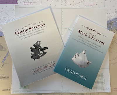
In early printings of our textbook GPS Backup with a Mark 3 Sextant we discussed the accuracy of the shortcut procedures using our custom sun almanac. These notes did not account for the type of sextant being used, but now that we have a dedicated online course for Backup Cel Nav that focuses on the Mark 3 sextant, it is now assumed that we would be using that type of sextant, so we need to fold in its own inherent uncertainties.
We have numerous examples that show that our custom long-term sun almanac can usually provide declination to within about ±1' and GHA to within ±2', and then we have approximations to the sun's semi-diameter (we call it 16' always) and we have abbreviated Refraction and Dip tables, so on the Latitude reckoning we have about a ± 2' uncertainty, with more like ± 3' on the Longitude reckonings.
We have a sextant (the Mark 3) that can only be read to ± 2’ and we have to effectively do this twice counting the index error measurement. Independent uncertainties add as the square root (sqrt) of the sum of the squares, so this sextant uncertainty is about sqrt (4 + 4) = 2.8'.
So for a Latitude sight we have a total uncertainty of about sqrt(2.8^2 + 2^2) or about 3.4'. We thus estimate that we can find latitude as:
This is to be compared to best possible with a good metal sextant, official Nautical Almanac data, in the hands of a navigator with a thousand sights experience who might get ± 0.5’ accuracy for either a Lat or an actual fix of both Latitude and Longitude. In the end, this best possible accuracy almost always depends on how well you account for the motion of the boat during the sight session. If you are moving at 7 kts and the sights take 30 min from first to last, then you have moved 3.5 nmi during that time, so we have to be very specific when we say we know where we were at any specific time to within 0.5 nmi or in fact to within 3 nmi.
For Lon we can assume the watch is right, so sextant error is not really a factor, and we are left with finding peak time of the LAN curve of sextant heights versus UTC, which we combine with our GHA uncertainty of ± 3'.

We can typically find the center of that curve to within about 1 minute if we have good sight data. Sometimes half that, but for safety let's call this a 1 minute uncertainty, which in turn leads to a Lon uncertainty of ± 15'. We combine this with the GHA uncertainty of ± 3' for a final value of sqrt(15^2 + 3^2) = 15.3. Thus for longitude sights at LAN we have:
We expand the 15' a bit as there can be other uncertainties if we are moving very much in the N-S direction during the time we are measuring the curve of Hs vs UTC. This distorts the Hs curve, and the center does not reflect the actual location of the sun crossing our meridian. For typical yachts this is usually a small factor.
This backup method has a large Lon uncertainty, but we must remember that this does not mean the Lon is wrong by that much. It most likely is not, but it is just uncertain by that much and we have to keep that in mind during decision making. Indeed if we do several LAN fixes over a few days and our DR is agreeing with these fixes, then we have learned that we are likely doing better than this large uncertainty.
We have numerous examples that show that our custom long-term sun almanac can usually provide declination to within about ±1' and GHA to within ±2', and then we have approximations to the sun's semi-diameter (we call it 16' always) and we have abbreviated Refraction and Dip tables, so on the Latitude reckoning we have about a ± 2' uncertainty, with more like ± 3' on the Longitude reckonings.
We have a sextant (the Mark 3) that can only be read to ± 2’ and we have to effectively do this twice counting the index error measurement. Independent uncertainties add as the square root (sqrt) of the sum of the squares, so this sextant uncertainty is about sqrt (4 + 4) = 2.8'.
So for a Latitude sight we have a total uncertainty of about sqrt(2.8^2 + 2^2) or about 3.4'. We thus estimate that we can find latitude as:
Latitude ± (3 to 5) nmi
This is to be compared to best possible with a good metal sextant, official Nautical Almanac data, in the hands of a navigator with a thousand sights experience who might get ± 0.5’ accuracy for either a Lat or an actual fix of both Latitude and Longitude. In the end, this best possible accuracy almost always depends on how well you account for the motion of the boat during the sight session. If you are moving at 7 kts and the sights take 30 min from first to last, then you have moved 3.5 nmi during that time, so we have to be very specific when we say we know where we were at any specific time to within 0.5 nmi or in fact to within 3 nmi.
For Lon we can assume the watch is right, so sextant error is not really a factor, and we are left with finding peak time of the LAN curve of sextant heights versus UTC, which we combine with our GHA uncertainty of ± 3'.

We can typically find the center of that curve to within about 1 minute if we have good sight data. Sometimes half that, but for safety let's call this a 1 minute uncertainty, which in turn leads to a Lon uncertainty of ± 15'. We combine this with the GHA uncertainty of ± 3' for a final value of sqrt(15^2 + 3^2) = 15.3. Thus for longitude sights at LAN we have:
Longitude ± (10' to 20')
We expand the 15' a bit as there can be other uncertainties if we are moving very much in the N-S direction during the time we are measuring the curve of Hs vs UTC. This distorts the Hs curve, and the center does not reflect the actual location of the sun crossing our meridian. For typical yachts this is usually a small factor.
This backup method has a large Lon uncertainty, but we must remember that this does not mean the Lon is wrong by that much. It most likely is not, but it is just uncertain by that much and we have to keep that in mind during decision making. Indeed if we do several LAN fixes over a few days and our DR is agreeing with these fixes, then we have learned that we are likely doing better than this large uncertainty.
Those reading the textbook, please note that it states that if we could know the peak height to within 30s, then the resulting Lon would be uncertain by 7.5', which it then rounds to 8'. That is true, but could be misleading, in that, as stated, it is not often we can be confident we know that midpoint of the curve that well. Fo more practical considerations, the ± 10' to 20' is better than thinking of this as ± 8'.
Also keep in mind that 10' of Lon at the equator is equal to 10 nmi, but 10' of Lon at 45º N is only 10' x cos (45) = 7 nmi. The Mercator projection pulls the meridians closer together at higher latitudes.
Sunday, April 5, 2020
Stargazing for Mariners: Northern Sky
We have a new Regiment of the North Star that can be used for finding latitude from Polaris without the official USNO annual nautical almanac. It can be used anytime you see Polaris, on any date or year. The method relies on identifying one of two stars, Alkaid at the tip of the handle of the Big Dipper and Segin, the trailing star of Cassiopeia on the other side of Polaris.

Both stars are trailing stars, meaning as the sky rotates, these are the stern of the constellation thought of as a boat sailing around the pole, once a day. They are also about equal distance from the pole and opposite to each other.
They are not bright stars. Alkaid at is the brightest of the Big Dipper stars, which as a group represent typical Magnitude 2 stars. The leading 3 stars of Cassiopeia are magnitude 2 and the trailing 3 are magnitude 3. Segin is the weakest of the lot at 3.3.
Because these stars are faint, we have to rely a lot on the pattern of the constellation. Alkaid is very easy, at the tip of the handle of the Big Dipper, but we need more help with segin.
Cassiopeia looks like an "M" from the Middle... meaning standing at the pole of the sky where Polaris is. Keeping that in mind, you can find this group, located about the same distance from the Pole as Polaris is on the other side.
Also the trailing loop of the "M" Cassiopeia is lazy, meaning not as tall, which also helps find this weak member of the group.

Other tips that help are these:
(1) Often the entire sky between Cassiopeia and the Big Dipper is blank except for two stars, and they will be Polaris and Kochab, one the Guards on the tip of the cup of the Little Dipper. Kochab, Polaris, and Alkaid are about the same brightness.
(2) The line between Segin and Alkaid passes very closely through the the pole of the sky, and if you zoomed in you would see that Polaris is on the Cassiopeia side.
(3) We are talking about a large span of the sky between Alkaid and Segin. At middle latitudes they span from about NW to NE in bearing.
(4) Since the stars are faint, when any part of either constellation is within some 10º of the horizon, they are likely to be extinguished by the (clear weather) atmosphere.

They are not bright stars. Alkaid at is the brightest of the Big Dipper stars, which as a group represent typical Magnitude 2 stars. The leading 3 stars of Cassiopeia are magnitude 2 and the trailing 3 are magnitude 3. Segin is the weakest of the lot at 3.3.
Because these stars are faint, we have to rely a lot on the pattern of the constellation. Alkaid is very easy, at the tip of the handle of the Big Dipper, but we need more help with segin.
Cassiopeia looks like an "M" from the Middle... meaning standing at the pole of the sky where Polaris is. Keeping that in mind, you can find this group, located about the same distance from the Pole as Polaris is on the other side.
Also the trailing loop of the "M" Cassiopeia is lazy, meaning not as tall, which also helps find this weak member of the group.
Other tips that help are these:
(1) Often the entire sky between Cassiopeia and the Big Dipper is blank except for two stars, and they will be Polaris and Kochab, one the Guards on the tip of the cup of the Little Dipper. Kochab, Polaris, and Alkaid are about the same brightness.
(2) The line between Segin and Alkaid passes very closely through the the pole of the sky, and if you zoomed in you would see that Polaris is on the Cassiopeia side.
(3) We are talking about a large span of the sky between Alkaid and Segin. At middle latitudes they span from about NW to NE in bearing.
(4) Since the stars are faint, when any part of either constellation is within some 10º of the horizon, they are likely to be extinguished by the (clear weather) atmosphere.
Wednesday, March 18, 2020
SCATSat — The Indian Scatterometer
At present we have 6 satellites providing scatterometer data, led by Metop-A, B, and C with their ASCAT Scatterometers. There is also the USN satellite Coriolis with the WindSAT instrument. Here I want to note the one from the Indian Space Research Organization (ISRO) called Oceansat 2, with its scatterometer called ScatSat. Valuable wind data from all five instruments are available in graphic format from the STAR Center (Google "ASCAT"; it will be the first link.) Graphic scatterometer data are also presented by KNMI at the EUMETSAT's Ocean and Sea Ice Satellite Application Facility (OSI SAF).

The data index pages from the STAR Center for five instruments are shown below.
 The ASCAT-A, B, and C instruments have the same pattern; they just come by at different times.




Title : ScatSat-1 winds unavailable
Message :
We are currently not receiving ScatSat-1 input data. The OSI SAF ScatSat-1
winds (OSI-112-a, OSI-112-b) are therefore not available. Note that you can
check the current processing status on
http://projects.knmi.nl/scatterometer/proc_status/ [1].
This service message has been published on OSI SAF web site :
http://www.osi-saf.org/?q=content/scatsat-1-winds-unavailable-32
This email has been sent to people who chose to subscribe to wind service
messages on OSI SAF web site.
You can update your subscriptions in your profile on http://www.osi-saf.org/
[1] http://projects.knmi.nl/scatterometer/proc_status/

Figure 1. SCAT stats with satellite id info needed for tracking. Data from China's National Satellite Ocean Application Service (NSOAS) instrument HY-2B is only available at KNMI/OSI-SAF.
The data index pages from the STAR Center for five instruments are shown below.


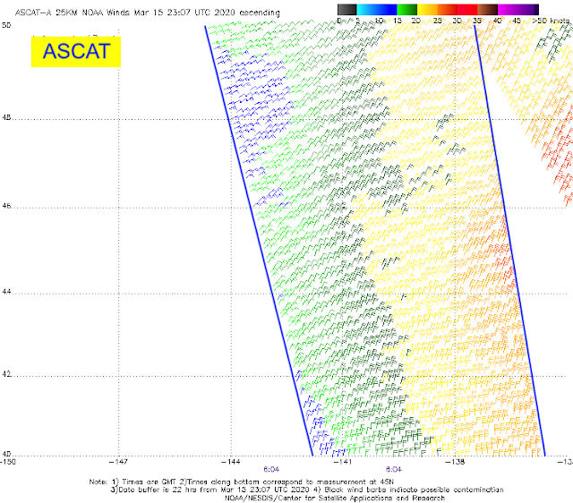
We see immediately that the wide swaths of the scatsat data are very attractive, but we need some confirmation that the data are dependable. One easy check is to see if they agree with the ASCAT data where there is overlap. The NWS highly regards the ASCAT data, which is used as input to model forecasts. A couple samples are below.


These two passes are about an hour apart, which is fairly close for this type of comparison. We see here very good agreement—also keep in mind the ScatSat is 12.5 km resolution compared to 25 for the ASCAT, so the details we see in ScatSat SW of Islas Marias could be real.
Another example:


These passes are at 0424 and 0451 respectively, which we read from the small purple times at the base of the diagrams.
Again we see good agreement and indeed we see the great value of the much larger data swath. Check out the Low in the bottom right, just missed in the ASCAT pass. We might even guess that this Low is moving north because of the stronger winds on the right-hand side.
And one more:


These passes are 0604 and 0451 respectively, 1 hr and 13 min apart. Not too bad for a rough comparison. We see wind directions good throughout and wind speeds seem consistent. The lower resolution ASCAT wind speeds are easier to read.
We can do a much broader comparison using a unique display tool at OSI SAF called Multi-platform Product viewer. This tool does exactly what we want. We choose a location of interest where there is ScatSat data and then with the tool we can look at all passes at about that time from the ASCAT instruments. Below is just one comparison off the coast of Perth, Australia, taken about 30 min apart. I will try to make a short video demo of the tool and post it here.

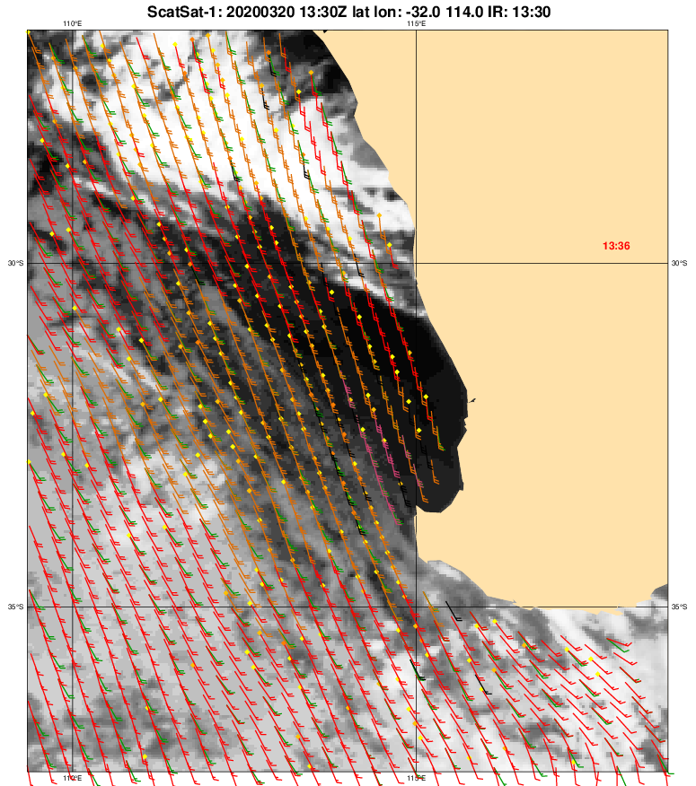
Wind speeds are a bit harder to read in the KNMI data as they include a cloud overlay and the color codes are tied to the Beaufort Force scale. The green arrows are the ECMWF model forecasts for the times of the satellite data, which is another neat feature of this display. We should not be too surprised by the general agreement observed as the ASCAT winds are used to seed the model runs.
In summary, this ScatSat data seems a boon to ocean navigation. You can get it the same way we get the ASCAT data underway with an email request to Saildocs. The key is knowing the file name to ask for. We have a graphic index to the file names in our textbook Modern Marine Weather. You can figure these on your own from the main index page at STAR Center. Just hover over a location to read the link. Then make a list.
The data images that cover the first 700 mi on the way from San Francisco to Hawaii would be this request to query@saildocs.com
send https://manati.star.nesdis.noaa.gov/sscat_images/noaa_cur_12km/zooms/WMBas38.png
send https://manati.star.nesdis.noaa.gov/sscat_images/noaa_cur_12km/zooms/WMBds38.png
This gets you the ascending and descending passes. When the images are full of data, the email is about 100 kB each. When empty of data, about 15 kB.
A good way to learn the value of this data is compare these images to the GFS or other models multiple times a day for several days. You will then be wanting to make your file list so you can ask for them at any time.
You can predict where the satellite will be using this link:

There are mobile apps and even screensavers that will track satellites that can be helpful.
Thank you India Space Research. Recall that we benefited from their OSCAT program for several years (2009 to 2014) when the amazing US QuikSCAT failed after a long and successful career.
[And a note of thanks to navigator Jeff Feehan, for directing me to the new Multi-Platform Product Viewer at KNMI, which was added here after the original was posted.]
__________
Note added Apr 7.
Since publication of this note, we have had two emails like the one below, indicating that the data are offline, and sure enough when this notice comes we do not see data at the STAR Center. In each case, we get another email the same day or next informing that the data are back online. So this is just a heads up that this is not an official source of data.
For what it is worth, the ASCAT data itself as obtained from the STAR Center is also described after all these years as still Experimental. But we have not seen outages of that data.
OSI SAF service message #2041
Sent on Tue, 07/04/2020 - 06:39 UTCTitle : ScatSat-1 winds unavailable
Message :
We are currently not receiving ScatSat-1 input data. The OSI SAF ScatSat-1
winds (OSI-112-a, OSI-112-b) are therefore not available. Note that you can
check the current processing status on
http://projects.knmi.nl/scatterometer/proc_status/ [1].
This service message has been published on OSI SAF web site :
http://www.osi-saf.org/?q=content/scatsat-1-winds-unavailable-32
This email has been sent to people who chose to subscribe to wind service
messages on OSI SAF web site.
You can update your subscriptions in your profile on http://www.osi-saf.org/
[1] http://projects.knmi.nl/scatterometer/proc_status/
Subscribe to:
Posts (Atom)