AIS shows where all ships and other commercial vessels within VHF radio range are located—they are required to have AIS—as well as all of the other vessels who have chosen to add optional AIS transmitters. AIS signals broadcasted by each vessel and the frequency of the broadcasts:

Notes:

The navigation status terms are taken directly from the International Navigation Rules (COLREGS). The definitions are in Rule 3.
The dimensions of a vessel are entered into the AIS unit to be broadcasted in a unique standard format internationally. It is designed to convey both overall dimensions as well as the location of the GPS. All computations of closest point of approach are computed between the GPS locations of the two vessels. When up close on large vessels this can make a crucial difference. When up close on large vessels this can make a crucial difference.

AIS signals are transmitted from vessel to vessel at VHF radio frequencies, same as used for voice communications. They are line of sight, so the heights of the antennas, as well as the transmitting power, determine the ultimate ranges.
There are a few simple, but important, basics: First, we need a way to display the targets. The higher end receivers include a display of text data (which is not so convenient if that is all you set up) and a graphic interface, but all receivers have an output in NMEA format. The simplest solution is input the NMEA signals to your electronic charting system (ECS). This might be some integrated package of instruments and display in a console navigation package, or without that, you can run echarts on a laptop. AIS receivers have a USB output that goes directly into your computer. The free navigation programs OpenCPN or qtVlm, for example, have many versatile AIS display options, as do all commercial ECS programs.
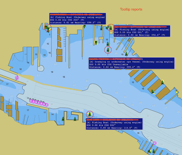
This screen cap from qtVlm displaying our live AIS data (we are 0.7 nmi NW of here) shows multiple tooltip reports of dynamic data, where we can note the speed and that the navigation status has not been set properly. This app adds an anchor ball to vessels with speeds zero. The other anchored targets have set the nav status properly. Ironically, the local maritime police station is just up the waterway from here, so they can always turn on the blue lights and head out to top off the coffee fund.
You have two ways to take part: You can install a receiver alone to learn about traffic around you, or you can install a transceiver, to both see AIS traffic and broadcast your own AIS information as well. Both are optional for recreational mariners, but transceivers are mandatory for commercial traffic. Receivers alone cost $60-$300, whereas transceivers are in the $800 to $3,000 range. At minimum, an AIS receiver should be considered standard electronic navigation equipment on all recreational vessels. Reception alone is very easy to set up; some new VHF radios include AIS output as an option, sharing the same antenna. Transceiver set-up is required to be assisted by a certified technician.
There are a few simple, but important, basics: First, we need a way to display the targets. The higher end receivers include a display of text data (which is not so convenient if that is all you set up) and a graphic interface, but all receivers have an output in NMEA format. The simplest solution is input the NMEA signals to your electronic charting system (ECS). This might be some integrated package of instruments and display in a console navigation package, or without that, you can run echarts on a laptop. AIS receivers have a USB output that goes directly into your computer. The free navigation programs OpenCPN or qtVlm, for example, have many versatile AIS display options, as do all commercial ECS programs.
The display and functionality that you get for monitoring and interacting with AIS traffic will always be much enhanced using one of the free or standard commercial ECS than it will be in the stand alone AIS displays.
Next, there are two classes of AIS signal transmission: Class-A transmission is the higher-end type required on ships and other commercial vessels, and Class-B transmission, available to vessels not required to carry Class A. All AIS receivers display both A and B signals, so the equipment decision is mostly receive only or transmit and receive. Recreational mariners can choose Class-A or Class-B transmission. Class A transceivers offer higher performance, but they cost more, so the Class-B transceivers are more popular with vessels not required to carry Class-A.
Vessels required to carry AIS Class A include: all commercial vessels over 65 ft, towing vessels over 26 ft with horsepower over 600, vessels certificated to carry more than 150 passengers, most dredging vessels, and all vessels with dangerous cargo.
Vessels required to carry AIS Class B if they do not carry Class A include: fishing industry vessels, and some passenger vessels that do not use traffic lanes nor have speeds over 14 kts. Vessels that would otherwise be required to carry AIS, but whose operations are restricted to a 1-nmi radius, can apply for an exemption to the AIS requirement. Other previous exemptions to the carriage rules all end on Mar 1, 2016. Vessels required to carry AIS must turn them on not later than 15 minutes before getting underway.
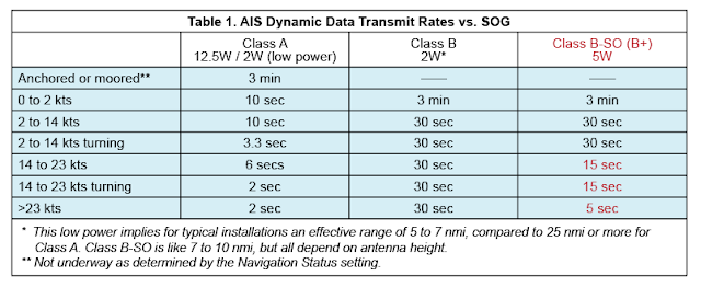
In short, ships, tow boats, and most larger commercial vessels use Class A, as do some fishing vessels, but most fishing vessels and most recreational vessels will be using Class B. The Table below compares the broadcasting schedules. It includes a special form of Class B called B-SO (self organizing) which has higher power than Class B and more frequent reports for fast vessels. It costs more (see notes at the end of this article), so would only be of interest to vessels that routinely travel at speeds higher than 14 kts or especially those higher than 23 kts, in which case one is really better off with Class A.
Next, there are two classes of AIS signal transmission: Class-A transmission is the higher-end type required on ships and other commercial vessels, and Class-B transmission, available to vessels not required to carry Class A. All AIS receivers display both A and B signals, so the equipment decision is mostly receive only or transmit and receive. Recreational mariners can choose Class-A or Class-B transmission. Class A transceivers offer higher performance, but they cost more, so the Class-B transceivers are more popular with vessels not required to carry Class-A.
Vessels required to carry AIS Class A include: all commercial vessels over 65 ft, towing vessels over 26 ft with horsepower over 600, vessels certificated to carry more than 150 passengers, most dredging vessels, and all vessels with dangerous cargo.
Vessels required to carry AIS Class B if they do not carry Class A include: fishing industry vessels, and some passenger vessels that do not use traffic lanes nor have speeds over 14 kts. Vessels that would otherwise be required to carry AIS, but whose operations are restricted to a 1-nmi radius, can apply for an exemption to the AIS requirement. Other previous exemptions to the carriage rules all end on Mar 1, 2016. Vessels required to carry AIS must turn them on not later than 15 minutes before getting underway.
In short, ships, tow boats, and most larger commercial vessels use Class A, as do some fishing vessels, but most fishing vessels and most recreational vessels will be using Class B. The Table below compares the broadcasting schedules. It includes a special form of Class B called B-SO (self organizing) which has higher power than Class B and more frequent reports for fast vessels. It costs more (see notes at the end of this article), so would only be of interest to vessels that routinely travel at speeds higher than 14 kts or especially those higher than 23 kts, in which case one is really better off with Class A.

Table adapted from our textbook Inland and Coastal Navigation.
Note this nuance about reporting rates: Navigation status is part of the dynamic data that is updated at a rate that depends on the SOG of the vessel, but there is an exception for when the vessel is not underway, namely anchored or moored. When anchored or moored, dynamic data is sent out only every 3 min. Once underway, i.e., not anchored or moored, the broadcast rate goes up tremendously to every 10s—even if the vessel speed is still zero. The vessel operator must manually set the navigation status in the AIS electronics... or an app that can control them.
There is a fine issued by the USCG to vessels who anchor or moor their vessels and leave the AIS on and in nav status "underway using engine," or anything else other than moored or anchored. The reason is at a broadcast rate of once per 10s all night and day as opposed to the proper once per 3 min they are using up AIS bandwidth unnecessarily, and in crowded harbors this can be an issue.
An example of the need for this is shown below.

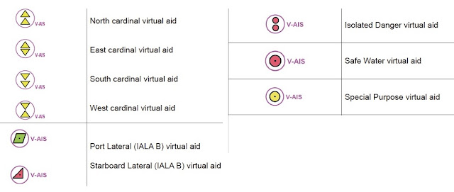
AIS can also be of great assistance in basic chart navigation in that prominent aids to navigation (buoys, lights, bridge pillar marks, etc) often send out AIS signals that show up on your echart display in the proper locations (labeled ATON).
Collision avoidance is also greatly enhanced by AIS because most echart programs read the AIS dynamic data of the targets and they know your own COG and SOG, so they can compute and display for you the closest point of approach (CPA) and the time to the CPA (TCPA) based on present conditions. Then as either of you alter course, you watch how this changes.
Search and rescue operations have special AIS modes that locate vessels and aircraft involved. There are even small, personal AIS transmitters that you can carry and activate if overboard so you show up on all local AIS receivers.
AIS reception also enhances your radar watch in the ways listed below.
AIS Synergy with Radar
1. AIS can find and communicate with targets hidden behind land or around corners that radar cannot see, and then plots them on an echart as if seen by conventional radar.
2. A radar echo can be identified or contacted by vessel name and vessel class rather than using a generic hail.
3. Target interactions (CPA, TCPA) can be improved because the target vessel is broadcasting performance data such COG and SOG and even a rate of turn when turning.
4. Extended tracking range is obtained since VHF communications reach out farther than typical radar ranges and thus passing arrangements can be made long before the vessels meet.
5. Ship target intentions will be more clear, and will help with maneuvering decisions, because the target’s destination, ETA, cargo, draft limitations, etc. are broadcast along with other AIS data.
6. Some ECS radar displays and all commercial vessel radars have an input for AIS signals so they can display the AIS targets overlaid on top of the radar targets.
There are numerous AIS sources online and in mobile apps that present near-live AIS signals for most waters of the world. In principle we could use our smartphone with a 4G connection to actually see the AIS targets around us when we are underway. This however, is not at all a dependable or safe approach. There is often a large delay between actual AIS reports and the ones we see in these apps, and this could lead to serious navigational errors.
A sample of AIS targets displayed in an echart program is in Figure 12.19-1, with a detailed view in Figure 12.19-2.


Virtual ATON symbols from our book Introduction to Electronic Chart Navigation. Plus NOAA has an extended discussion of virtual AIS aids
Collision avoidance is also greatly enhanced by AIS because most echart programs read the AIS dynamic data of the targets and they know your own COG and SOG, so they can compute and display for you the closest point of approach (CPA) and the time to the CPA (TCPA) based on present conditions. Then as either of you alter course, you watch how this changes.
Search and rescue operations have special AIS modes that locate vessels and aircraft involved. There are even small, personal AIS transmitters that you can carry and activate if overboard so you show up on all local AIS receivers.
AIS reception also enhances your radar watch in the ways listed below.
AIS Synergy with Radar
1. AIS can find and communicate with targets hidden behind land or around corners that radar cannot see, and then plots them on an echart as if seen by conventional radar.
2. A radar echo can be identified or contacted by vessel name and vessel class rather than using a generic hail.
3. Target interactions (CPA, TCPA) can be improved because the target vessel is broadcasting performance data such COG and SOG and even a rate of turn when turning.
4. Extended tracking range is obtained since VHF communications reach out farther than typical radar ranges and thus passing arrangements can be made long before the vessels meet.
5. Ship target intentions will be more clear, and will help with maneuvering decisions, because the target’s destination, ETA, cargo, draft limitations, etc. are broadcast along with other AIS data.
6. Some ECS radar displays and all commercial vessel radars have an input for AIS signals so they can display the AIS targets overlaid on top of the radar targets.
For completeness, we add...
Advantages radar retains over AIS for collision avoidance
1. Radar range and bearing are direct measurements, more "tangible" or "visual" to many navigators, compared to the "black box" digital reports from GPS or AIS that require external inputs, and thus a higher level of faith.
2. Radar data are instantaneous, whereas AIS always includes some level of delay.
3. Not all vessels carry, or have turned on, a transmitting AIS signal, and internet AIS are always much delayed, whereas radar works, even for a target vessel drifting with no power... or log!
4. More remote an issue, but radar is essentially immune from spoofing, whereas the GPS that AIS depends upon is notoriously easy to spoof.
5. Radar being wholly self contained is independent of available public services needed by GPS and AIS.
There are numerous AIS sources online and in mobile apps that present near-live AIS signals for most waters of the world. In principle we could use our smartphone with a 4G connection to actually see the AIS targets around us when we are underway. This however, is not at all a dependable or safe approach. There is often a large delay between actual AIS reports and the ones we see in these apps, and this could lead to serious navigational errors.
A sample of AIS targets displayed in an echart program is in Figure 12.19-1, with a detailed view in Figure 12.19-2.
 |
Figure 12.19-1. AIS targets viewed in OpenCPN. Active or selected target is the one whose information is being displayed (marked with a square box), else the targets are called sleeping targets, which is misleading—they are sleeping only in that you have not chosen to read the data. Echart programs often have ways to annotate or color the symbols beyond the standard format. Projected vector lines show COG and SOG. The above are set to show 3-minute projected positions. Sometimes we can detect current when the true heading line is different from the COG. Destination information when present is more often wrong than right. This has to be manually updated and often gets overlooked. |
 |
| Figure 12.19-2. ECS display can be set to show actual target size and precise location when zoomed in. On the right is our vessel, also scaled to right dimensions and precise location. We can see that the target heading and COG are different. This is viewed with OpenCPN. |
A simulated vessel interacting with 3 live AIS targets in qtVlm. This type of study is a unique feature of qtVlm. Here we see two tooltip reports of CPA data and one Details report for the other target. The red glow around the collision risk targets grows and pulses as they get closer. (Click image, then right click to open in new tab, and zoom in to see details.)
____________________
These notes were adapted from our text Inland and Coastal Navigation, 2nd Ed. We will follow up with a report on several specific AIS receivers, including this neat unit that is made near us called the dAISy. It is powered via the USB that connects it to your computer.
 |
| A dAISy with a ducky (not included). It does include an adapter to a standard antenna connector. |
____________
See also our related notes:
References (We are lucky here, there are excellent references online.)
AIS signal structure and protocal (by Eric Raymond)
Wiki on AIS.
Added 3/23/17. Good overview looking ahead: AIS Meets IoT: How Technology is Set to Transform Global Ocean Trade and Supply Chain Efficiency
Wiki on AIS.
Added 3/23/17. Good overview looking ahead: AIS Meets IoT: How Technology is Set to Transform Global Ocean Trade and Supply Chain Efficiency
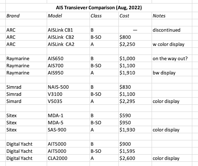
Added 4/6/22, updated 1/27/26. Below is a nice summary of the comparison of Class A and Class B AIS from the excellent, well illustrated overview of AIS produced by Digital Yacht in the UK.

Added 8/21/22. Digital Yacht also has a good overview of Class B-SO, which they call B+. (Note Class B does not have an "anchored or moored" mode. They just mean here that a vessel with speed about 0 is 3 min.)
Below is a comparison we made for relative prices of these models.

The prices we found here are consistent with the summary from the USCG. Besides the extra power which would mean being seen a few miles farther off, the main advantage goes to vessels who routinely travel at >14 kts and almost required for those routinely going more than 23 kts, but in that case, the Class A would be preferred.
In our live AIS receiver we have here at Starpath we see a fairly large number of B+ units, which might reflect that standard installs just default to that model, independent of its actual need.
3 comments:
Just my thought- I considered the reporting schedule of Class A vs Class B AIS. I chose to install a Class A system on our somewhat fast powerboat. Our normal cruising speed is 20kts+ with a top speed of over 45kt. The rapid position broadcasting is critical. 30 seconds and we could be a 1/4 a mile from we are actually reporting. I don't believe the Class A/B differences get evaluated often enough. Sailboats & displacement boats do fine with a Class B. The cost differential is large, the installation is slightly more difficult, but I believe the safety due to the increased accuracy is very much worth the trouble.
I agree completely. If the decision is made to be seen, I think all vessels might consider the advantages of A over B, especially in the ocean where the range will be much farther as well. In fact, a legal option of any viewer is to shut off showing the B-class signals, which could be attractive to a ship in a very busy harbor, but I do not know how often this might be done. The IHO standards require that any filter set on the display must be shown prominently so it is not forgotten.
Hi David,
I am an active duty Naval Officer and graduate student working on my master's thesis. My topic deals with trying to create an automated system for predicting future ship movements using historical AIS data. I really like this picture you use to demonstrate what AIS is and how it works, and I was wondering if it is ok with you if I use this same picture for my thesis? Please contact me at smbay@nps.edu if you have any questions.
Post a Comment