Noted added July, 2023. The NDFD oceanic data have been discontinued for some time now. The counterpart would be the National Blend of Models, Oceanic, which should incorporate the information of the previous data set. NDFD CONUS is still available.
Note added Dec. 22, 2025. The oceanic sector is back, so several links and sections below are updated, but we are not quite done with this.
__________
And this early note: this is wind (and waves) only data, no pressure—"waves" in NDFD means significant wave height of the combined seas. When pressure is needed, the NAM data will likely be best source for that, or HRRR where available. Also the present discussion is a pursuit of the best possible data, which might not always differ significantly from other good sources for practical routing applications, but we will not know that till we start using it, or at least start comparing it with other sources.
When we get the NDFD data, it loads into our GRIB viewer or navigation program just as any model prediction might, but it pays to remember that this is not a model prediction, and it is a very complex dataset. To say, for example, "I am using the NDFD forecast for my routing" does not adequately specify what exactly you are using. There are several options, which differ notably. Likewise, having a source of weather data that simply specifies "NDFD" does not answer that question. We would need to look at that wind data specifically to see what it actually is, keeping in mind what the options are. The goal here is to outline options available and how they differ.
There are three basic categories or sectors of NDFD data: Oceanic, CONUS (continental US), and Regional. The coverage areas of these categories are shown in Figure 1, adapted from an early version of the NDFD website, now removed.

Figure 1. NDFD sectors. Purple areas are the NDFD Oceanic coverage. Red inserts mark the CONUS, and three regional areas. There is also a small regional area around Guam. Where sectors overlap, there are two sets of data available, with the CONUS or regional being the higher res and fresher forecasts.
Table 1 shows the specs for the data of these sectors, with important notes to follow.
(12/22/25: These data are a bit out of date, we will fix this shortly)

All of these data sets are available in GRIB2 format directly from NOAA's Meteorological Development Laboratory, but it is a two-step process to get them that way. Various parts of the full set are available from Saildocs or LuckGrib. We come back to sources after looking at specific regions covered and associated notes. There is, for example, a 5-km set of CONUS data available, which is not in the Table as I cannot see a role for it. Most GRIB downloaders let us select the resolution we want, which is effectively downsampling the higher-res data.
The frequent updates of the CONUS data may not affect your specific data set. The full national set is updated every 30 min, but any one local area might not have updated in that time period, so the area you care about could be new only every hour or so, or maybe longer. The regional sets are in principle different, as they are controlled by their individual weather offices.
Historically, the frequent updates could periodically affect the time steps where it is changing from, say, 3h steps to 6h steps. You may have a 4h step at the transition, or a 2h step. It will be up to the display or routing software to note this and handle it appropriately. I have also seen individual steps missing at times. In short, if something does not look right, try downloading it again, or wait 30 min and do so. Ultimately the datasets are controlled by the local weather offices and perhaps even by the specific forecaster in charge at the time. The process of how the dataset is constructed is explained in this AMS article from 2002 that introduced the program... noting it was the first of its kind in the world.
When we have a choice of CONUS or oceanic, then the CONUS would be the obvious choice as it is four times higher resolution and is updated far more often. If your source does not identify the NDFD sector, then chances are it is oceanic. Saildocs, for example, so far has only the oceanic sector—even if you zoom in to Hawaii, you get the oceanic data (0.13º resolution and not the HI regional data at 0.024º resolution). I anticipate that this data will become more readily available to mariners in the not-too-distant future, but there are a few hurdles to cross, as noted later.
In practice, the precise locations of the boundaries could be crucial. The oceanic region, for example, just makes it out to Bermuda as shown in Figure 2.


Figure 2. Showing the corner of the oceanic NDFD near Bermuda
On the route Marion to Bermuda, for example, you could use the superior CONUS for most of the route, then switch to oceanic, as shown in Figure 3.

Figure 3. Boundary between CONUS and oceanic coverage on a Bermuda route

Figure 4. HI Regional and oceanic coverage. In the oceanic data set the resolution is 5.4 nmi; in the regional data set resolution is 1.35 nmi.
The CONUS coverage is rather awkward in the Pacific Northwest as shown in Figure 5. The data end right at the Canadian border, in the middle of Strait of Juan de Fuca. So alternatives such as NAM or HRRR could be more convenient.

Figure 5. CONUS limits in the Strait of Juan de Fuca and San Juan Islands. The oceanic database has the same boundary in this region. Note that the HRRR data (updated hourly) does cover the full Strait and San Juan Islands, and is likely as good, but it goes out only 18h.
To help plan the potential use of the NDFD, we have made gpx files that mark the boundaries of the regions. These can be loaded into any navigation program to outline where the data are available, then just shown as needed. Download from this link:
These gpx files are shown loaded below loaded into OpenCPN, followed by a related import to Expedition. OpenCPN will not yet display the regional or CONUS data (grb2 format), but it will show the oceanic sector provided by Saildocs, who have converted the grb2 to grb1.

Figure 6. NDFD boundaries imported into OpenCPN as a set of gpx files. Red is CONUS; blue oceanic.

Figure 7. Detail of Figure 6 at the approach to Strait of Juan de Fuca. Red is CONUS.
On US Inland waters, the CONUS and oceanic limits are the same, but in the ocean they differ in this region.
Below shows these boundaries imported to Expedition as race notes. Download the link below (the borders made into Race Notes format), and save to c:\Program Data\Expedition\RaceNotes. Then in the Sail Panel, Race Notes section, Save all of your existing notes, clear the notes, then choose Open. Once imported, use Edit Notes to maybe change color of CONUS to highlight difference from oceanic; on the Oceanic note, change to rhumb lines rather than great circles; then lock them all, and save the set. Download from this link:
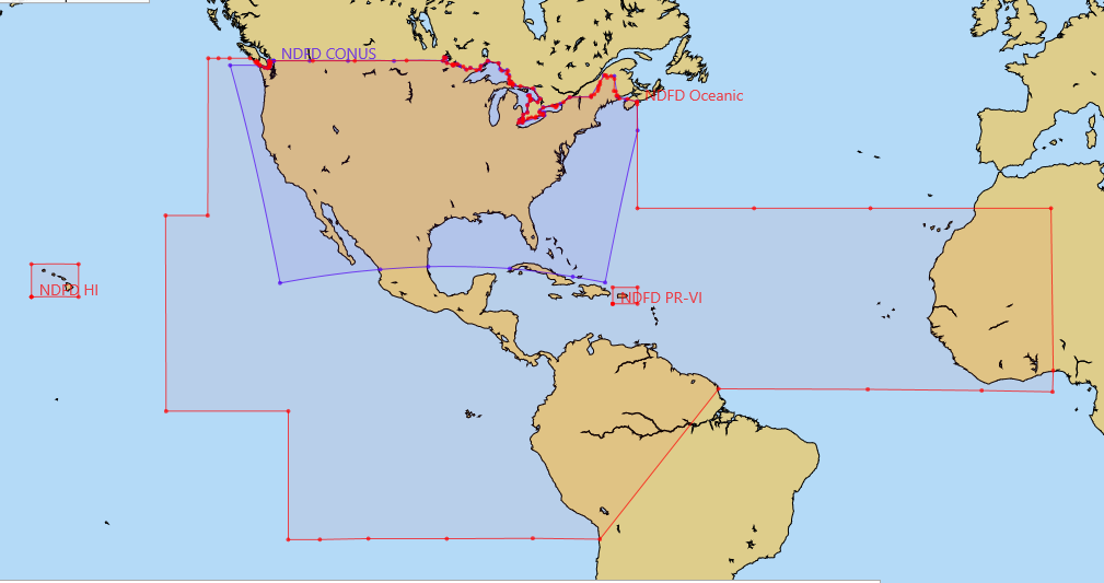
Figure 8. NDFD regions displayed as race notes in Expedition. CONUS data are created in a Lambert projection (rather than mercator), which accounts for the shape shown. There are data on land for the CONUS sector—much better and more detailed than our local TV weather!—but there are no land data in the oceanic sector for Mexico, South America or Africa. These borders follow the coast lines, though not shown that way above.
Below shows a comparison of the CONUS and oceanic data for San Francisco Bay area.


Even though the winds in the early hours of a forecast might be very similar with just higher res in the CONUS, at later hours, the CONUS could be far superior if the forecast changes. The oceanic dataset cannot acknowledge such a change for 6h. This can make a big difference with frontal passage anywhere, and could be really crucial in the Atlantic when tropical storms move north along the Gulf Stream. Recall that the National Hurricane Center (NHC) are contributors to the NDFD, so I would hope that their datasets include all information from the latest Advisories. (This will be a good research project the next time we have a TC moving north in the Atlantic. If there are any volunteers, let us know and we can explain how to set this up for the comparison.)
In principle, the h0 "forecast" of either dataset should be effectively a surface analysis at the time of issue, incorporating latest ship and other reports. This too should be easy to test by comparing the CONUS and Oceanic at synoptic times with the graphic maps of the surface analyses. Likewise, at these times, we can also compare the NDFD h48 and h96 forecasts with the graphic forecasts from the Ocean Prediction Center (OPC).
Sadly, there are no pressure forecasts in the NDFD. I am still trying to learn why. It would seem that if they can forecast anything, they could forecast pressure. I think the folks in charge do not appreciate how valuable pressure is to mariners. It is our best way to evaluate and monitor a forecast and indeed the actual weather. In contrast to wind speed and direction, it is easy to measure very accurate pressure. When I learn more on why it is not included, I will edit this paragraph. Pressure forecasts have been a crucial part of maritime weather forecasting since the very concept of forecasting was invented by Robert FitzRoy, some 150 years ago.
First a minor detail. All the NDFD original data described the wind provided as at the "surface," just as the WW3 model wind forecasts are presented. In contrast, all other models and txt forecasts give winds at 10m, and then we use various algorithms to convert that wind speed to other elevations in the optimum routing process.
Well... that is a bit misleading, and it is fair to assume that all reported winds are normalized to 10m. Why the GRIB parameters for these use "surface" rather than "10 meter" is not clear, but here is the statement on WW3. The wind in the NDFD is also not on the surface, despite that statement in the grib files themselves. NDFD winds are indeed at 10m (see NDFD element definitions), as we might guess they would be. This is just another example of how the government supports navigation schools.


Figure 9. Top, CONUS (2.5 km updated every 30 min). Bottom, Oceanic (10 km updated every 6 hr). Note there is no interpolation in either display; one wind arrow per grid point.
Even though the winds in the early hours of a forecast might be very similar with just higher res in the CONUS, at later hours, the CONUS could be far superior if the forecast changes. The oceanic dataset cannot acknowledge such a change for 6h. This can make a big difference with frontal passage anywhere, and could be really crucial in the Atlantic when tropical storms move north along the Gulf Stream. Recall that the National Hurricane Center (NHC) are contributors to the NDFD, so I would hope that their datasets include all information from the latest Advisories. (This will be a good research project the next time we have a TC moving north in the Atlantic. If there are any volunteers, let us know and we can explain how to set this up for the comparison.)
In principle, the h0 "forecast" of either dataset should be effectively a surface analysis at the time of issue, incorporating latest ship and other reports. This too should be easy to test by comparing the CONUS and Oceanic at synoptic times with the graphic maps of the surface analyses. Likewise, at these times, we can also compare the NDFD h48 and h96 forecasts with the graphic forecasts from the Ocean Prediction Center (OPC).
Sadly, there are no pressure forecasts in the NDFD. I am still trying to learn why. It would seem that if they can forecast anything, they could forecast pressure. I think the folks in charge do not appreciate how valuable pressure is to mariners. It is our best way to evaluate and monitor a forecast and indeed the actual weather. In contrast to wind speed and direction, it is easy to measure very accurate pressure. When I learn more on why it is not included, I will edit this paragraph. Pressure forecasts have been a crucial part of maritime weather forecasting since the very concept of forecasting was invented by Robert FitzRoy, some 150 years ago.
The Nitty Gritty
First a minor detail. All the NDFD original data described the wind provided as at the "surface," just as the WW3 model wind forecasts are presented. In contrast, all other models and txt forecasts give winds at 10m, and then we use various algorithms to convert that wind speed to other elevations in the optimum routing process.
Well... that is a bit misleading, and it is fair to assume that all reported winds are normalized to 10m. Why the GRIB parameters for these use "surface" rather than "10 meter" is not clear, but here is the statement on WW3. The wind in the NDFD is also not on the surface, despite that statement in the grib files themselves. NDFD winds are indeed at 10m (see NDFD element definitions), as we might guess they would be. This is just another example of how the government supports navigation schools.
(12/22/25: the above paragraph is likely all outdated now.)
NOAA provides the NDFD data in grib 2 format (see sector specs). There are not yet many grib viewers or navigation programs, however, that accept wind data in grb2 format. Expedition is one popular navigation program that does support grb2, which means it will load and display the native CONUS data, and qtVlm is another that can do it.
The Mac app LuckGrib has played a key role in the introduction of this data to mariners worldwide. Not only does this program display all the NDFD data, it is a super convenient source for the data files themselves, with a Grib File Explorer function that tells all about each file it shows. If you use Expedition (PC only) for racing navigation and have access to a Mac, you can download the files with LuckGrib, then export them to use in Expedition. The process of getting the native NDFD files on your own with a PC, however, is easily done, as explained below.
The key datafile you can get this way (LuckGrib to Expedition, or download and process on your own) is the CONUS sector. This data comes in a lambert projection, and Expedition can read and display that. The native oceanic sector and hi-res regional sectors are presented in a mercator projection, and the latest version Expedition will import these as well for routing or comparison with model output, as will qtVlm.
There are other options for the oceanic sector. Saildocs has independently converted the mercator oceanic data to a grb1 format, which will then read in just about any navigation program. There is some loss in precision during the conversion process, so when possible the original grb2 mercator format would be preferred, but the existing conversions from Saildocs does allow mariners with just about any navigation program or grib viewer to see and use the oceanic dataset. Both sources refer to the product as simply "NDFD," but this is the NDFD oceanic sector data converted to grb1.
We are currently doing a study of NDFD CONUS vs oceanic, NAM, HRRR, and Predict wind. The forecasts are then compared to buoy data at several locations near San Francisco. I will follow up with that when done.
Failing that, one solution I have found so far takes just a few steps (short description, followed by a video illustration). A key factor here is to note that the grb2 files from NOAA do not have the .grb2 extension. They are in a .bin format. Expedition and LuckGrib can read that extension as is. For qtVlm, just change the combined file extension to .grb. Note that most programs do not distinguish between extensions, grb, grb1 and grb2.
NOAA provides the NDFD data in grib 2 format (see sector specs). There are not yet many grib viewers or navigation programs, however, that accept wind data in grb2 format. Expedition is one popular navigation program that does support grb2, which means it will load and display the native CONUS data, and qtVlm is another that can do it.
The Mac app LuckGrib has played a key role in the introduction of this data to mariners worldwide. Not only does this program display all the NDFD data, it is a super convenient source for the data files themselves, with a Grib File Explorer function that tells all about each file it shows. If you use Expedition (PC only) for racing navigation and have access to a Mac, you can download the files with LuckGrib, then export them to use in Expedition. The process of getting the native NDFD files on your own with a PC, however, is easily done, as explained below.
The key datafile you can get this way (LuckGrib to Expedition, or download and process on your own) is the CONUS sector. This data comes in a lambert projection, and Expedition can read and display that. The native oceanic sector and hi-res regional sectors are presented in a mercator projection, and the latest version Expedition will import these as well for routing or comparison with model output, as will qtVlm.
There are other options for the oceanic sector. Saildocs has independently converted the mercator oceanic data to a grb1 format, which will then read in just about any navigation program. There is some loss in precision during the conversion process, so when possible the original grb2 mercator format would be preferred, but the existing conversions from Saildocs does allow mariners with just about any navigation program or grib viewer to see and use the oceanic dataset. Both sources refer to the product as simply "NDFD," but this is the NDFD oceanic sector data converted to grb1.
We are currently doing a study of NDFD CONUS vs oceanic, NAM, HRRR, and Predict wind. The forecasts are then compared to buoy data at several locations near San Francisco. I will follow up with that when done.
Downloading the data
For those who might want to experiment with the native NDFD sector files from NOAA, but do not have access to LuckGrib (which hands them to you with a button click) then here is an outline of the process. You can do this on a PC or a Mac.
First note that in principle there is an easy solution for getting any Lat-Lon rectangle of the CONUS data at this link custom dgrib requests, but I have not figuired out how to use this yet.
Next, the NDFD native data present wind speed and wind direction in two different files. This does not affect LuckGrib, which downloads all the files directly. Expedition can read two files at once, so we do not have to combine these externally. We just drag the two files onto the Expedition screen and they load and show proper wind vectors. qtVlm has a convenient grib combining function, so we combine the two in one short step and load the combo to see the wind.
The links on this spreadsheet from NOAA list the data available. Every element of every sector is there in different subfolders, but we will here be concentrating on wind and waves.
New addition to this article on 12/22/25:
With recent news from OPC that they are newly working on this program, I have updated this section (and parts above) on how to get the data. The data are at this location:
Which has these sub folders:
AR.alaska/AR.midatlan/AR.neast/AR.crgrlake/AR.nhemi/AR.crmissvy/AR.npacocn/AR.crplains/AR.nplains/AR.crrocks/AR.nrockies/AR.ergrlake/AR.guam/AR.pacnwest/AR.pacswest/
In each folder, choose days 1-3, or 4-7, and sometimes longer
Then see all the parameters.
We want
ds.wspd.binds.wdir.binds.wave.bin
Again, this would primarily be for the CONUS and for the regional data. For the oceanic we can get them from Saildocs with Lat-Lon boundaries.
ie, mail to query at saildocs.com
SEND NDFD:10S,10N,100W,80W|0.12,0.12|0,6..120|wind,waves
this will get you the oceanic data for wind and waves
/SL.us008001/ST.opnl/DF.gr2/DC.ndfd/AR.conus/VP.001-003/ds.wdir.bin
Check Table 1 above for the forecast times and update schedule. Remember the files always have the same name when downloaded, so we have to keep track of what we work with. These are files you can practice with, as illustrated in the videos below. In short, download a set and load all three into Expedition Grib folder, or just drag them onto the open Expedition chart window.
Note: For some reason, not yet understood, when you download the CONUS data by regional sector, as in the above example, we get only half the promised resolution... ie we get 2.75 nmi per grid point, whereas if we download the same region from the full CONUS file, we get the promised 1.3 nmi. Still much to be learned about this dataset.
Note from 12/22/25: luckily the section below is now wrong and the HI data look just fine so far. Remember, it was originally from 2017!
--------- not done updating beyond here 12/22/25.
[Note added 5/12. I originally had as an example here the HI regional data, but that sector is not yet consistent in either time steps or in spacial coverage. So we have to wait on that one. I can only note that this observation is not consistent with published goals of the NDFD. In the NDFD Operations Concept article we find this statement of one of its goals: to provide information that is "up-to-date, available on demand, and provided with spatial and temporal consistency to help users make more informed decisions."]
If the "custom degrib" link given above worked as we might hope, we could ask for specific Lat-Lon region within the CONUS, but in lieu of that we have to ask for a full file. The SE CONUS sector (covers both coasts of FL) is a total of 900 kb for wind speed and direction.
If the "custom degrib" link given above worked as we might hope, we could ask for specific Lat-Lon region within the CONUS, but in lieu of that we have to ask for a full file. The SE CONUS sector (covers both coasts of FL) is a total of 900 kb for wind speed and direction.
There is a stand alone executable of dgrib, which can be used to download the files, which will keep them sorted timewise. But I do not yet know how to specify Lat-Lon window with
that.
I am very excited about the high value of this NDFD data for maritime use underway, but have to admit to learning more about it every day. I will update or correct this article as needed. We have always stressed how important it is to use the forecasts of human intelligence to test the unvetted model forecasts, and this dataset offers an ideal way to do so, and in principle it should serve as the best data for optimum routing... in regions where the data are consistent in format.
_____
Note on getting archived NDFD data.
4 comments:
David,
Continuing the discussion about OpenCPN.....
Grib 2 files from these 2 sources works for me on OpenCPN:
http://dd.meteo.gc.ca/model_gem_regional/coupled/gulf_st-lawrence/grib2/00/002/
http://195.154.231.142/HD/
I picked these sources from a recent thread on http://www.cruisersforum.com/forums/f134/
I don't think that OpenCPN can read the .bin format directly.
Lamberts Conformal Conical is not directly supported.It may be possible via the projection plugin (probably in a beta stage).
If OpenCPN fails to read grib2 files, it must be regarded as a bug.
Your input is very valuable, and I will push this on the OpenCPN forum.
Thomas Hockne
aka "Cagney" on the Cruisers forum.
News on changes that affect the NDFD data are anticipated in July 2017.
See http://www.nws.noaa.gov/os/notification/scn17-59nbm3aaa.htm
These comments on this article have been moved here from a different posting. It seems we were having an issue with the comments functionality. So for now, these are just manually moved here.
Anonymous May 14, 2017 at 10:55 AM
David , Opencpn can read .grb2 files since the release of version 4.4, the current version is 4.6.1. Unfortunately this is not yet mentioned in the documentation. The free grib viewer zyGrib is also able to read .grb2 files. Thomas Hockne
David Burch May 14, 2017 at 12:41 PM We have a recent article on NDFD that includes links to grib2 files. I have tried these in OpenCPN 4.61 on both mac and pc, and cannot get them to load. Can you tell me a source for grb2 files you refer to that will open in opencpn? Also maybe we can move this discussion to that article which is on this topic. One just before this one. thanks. the grb2 fomat comes in several projections and each has to be treated separately. CONUS is Lambert, oceanic and regional are mercator. Thanks again for the note. it will be extremely valuable if opencpn can read these NDFD files.
David Burch May 14, 2017 at 4:37 PM
I should add too that we are discussing in that article the native NDFD files and specifically the CONUS sector (a lambert projection). The oceanic sector (mercator) converted to grb1 by saildcos will run nicely in opencpn, and remains a valuable resource, but the CONUS data appear to be superior where we can get it, but it has to be tested.
Anonymous May 25, 2017 at 6:49 AM
OpenCPN reads .grib2 and .grb2 files just fine. I just tested with files from these pages:
http://dd.meteo.gc.ca/model_gem_regional/coupled/gulf_st-lawrence/grib2/00/002/
http://195.154.231.142/HD/
David Burch May 25, 2017 at 4:39 PM
Hi Thomas, these are both very nice grib sets and you are right they open nicely in OpenCPN. Thank you for the examples. They are a good source of data. The former from CHO and the latter from MeteoFrance. These are grib 2 format, but this format can come in several map projections. These two sources happen to be in a plain Lat-Lon grid, whereas NDFD comes in either Lambert, Mercator, or Polar Azimuthal. Almost all grib viewers will read the Lat-Lon grid, in grb2 or grb1, but it is up to the viewer to interpret the other projections. I would say there is no hope that the US will change this or offer an option. Thus we need to ask the viewer programmers to address this (as several have) or with some effort we can do the conversion ourselves using wgrib2 ( http://www.cpc.ncep.noaa.gov/products/wesley/wgrib2/ ). The use of that program was in the original article, but then removed as it was not needed. Now maybe there is call for that again.
Dear David, I liked this post about NDFD a lot! I also downloaded oceanic grib files via Saildocs but they only offer the datasets (wind and wave) as described above. On the internet I found this status doc from 2018 (https://www.weather.gov/media/mdl/NDFD_element_status_Feb18.pdf) wich tells me that oceanic should also have parameters such as "Hazards" and "Tropical Cyclone Surface Wind Speeds Probabilities" and "Gusts". Do you know anything if they will be included in Sildocs download any time?
Regards Alex
SV FITZROY
Post a Comment