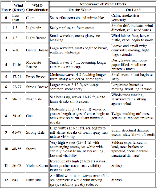
The number on the left is called the Beaufort force number (BFN). Used in this manner, it is similar to using feathers on wind barbs on weather maps, which are always ± 2.5 kts. That is, one long and one short feather is nominally 15 kts, but is actually 15 kts ± 2.5 kts. A forecasted 17.5 kt wind would get the same wind barb display as one with 12.5 kts. We do not switch to two long feathers (nominally 20 kts) until 17.6 kts. ( I am not sure how the programs handle exactly 0.5 in this application.... they likely round up.)
The range of wind speeds within a specific BFN varies from 1 to 4 kts, but the average is about 2.5, same as the wind feather spread.
This note is to document a way to estimate wind from the BFN that we have used for years, but it came up in class today that we do not have this written out anywhere. It can be useful for those of us that are not accustomed to using BFN for windspeed designation. Furthermore, the wind roses on Pilot charts are often expressed using BFN, in that they show arrows with feathers, and in their system the number of feathers is the BFN, as shown below.
Figure 8.2-5 Section of a U.S. Pilot Chart. August winds near Cuba are given for each 2° of Lat-Lon. In the top right corner, the wind has a 39% probability of being from the east and 32% from the southeast. When the probability is less than 29%, it is represented by the length of the line, which is relative to a printed scale not shown here.
Predicted wind speeds are in Beaufort Force numbers, with each side of a feather being one number. In the top right the E and SE winds are Force 4 (11 to 16 kts), the much less likely NE wind would be Force 3 (7 to 10 kts).
The circled numbers are the percentage calms at each location. The current arrows in this chart are marked with speed in kts with a “steadiness” depicted by the line style: a heavy line means 50% steady, thinner lines means 25% to 50% steady, and a dashed current arrow means steadiness is less than 25%. See the steady Gulf Stream near Florida, and the weak unsteady back-stream south of Cuba. Other Pilot Charts do not have the steadiness data and some give the speeds. From Modern Marine Weather, 2nd ed.
Thus we create a short cut for figuring wind speeds from BFN, namely Wind speed (in kts) = BFN x 6 - 10, or just
kts = 6N-10.
Below are statistics and errors of this method. It does not work for n = 1 (1-3 kts), nor n = 2 (4-6 kts).


No comments:
Post a Comment