The short answer for many mariners is: nothing changes—but that takes some explaining.
The official NOAA tide and current books of 1995 to 2020 looked something like these below from one particular printer—but there were several different printers, with different cover designs for the same content.

Books with this full range of content are no longer supported by NOAA. We may see versions of the four on the left from third party printers this year, but they will not include any of the international data, and the two on the right will not be available. NOAA no longer has that international data to distribute, except for US territories.
The reference station predictions included (now called harmonic stations) would be official NOAA data, indicated by the presence of the NOAA logo on each page, but the subordinate station corrections in Table 2 (if present) would be the 2020 versions, because these correction tables are not supported beyond 2020. The 2020 tide station corrections are likely to be good for 2021, and the current station corrections are likely to be close, but chances are these 2020 Table 2 corrections will become less dependable as time goes by. Recall that Table 2 has always described its corrections as providing only "reasonable approximations of the current at the subordinate stations." The tide heights version includes similar clarifications.
For those who historically obtained their subordinate station data from books like these there will be new procedures or new products called for. NOAA no longer produces tables of corrections, but they do indeed provide the full daily predictions for all stations, harmonic and subordinate at their website
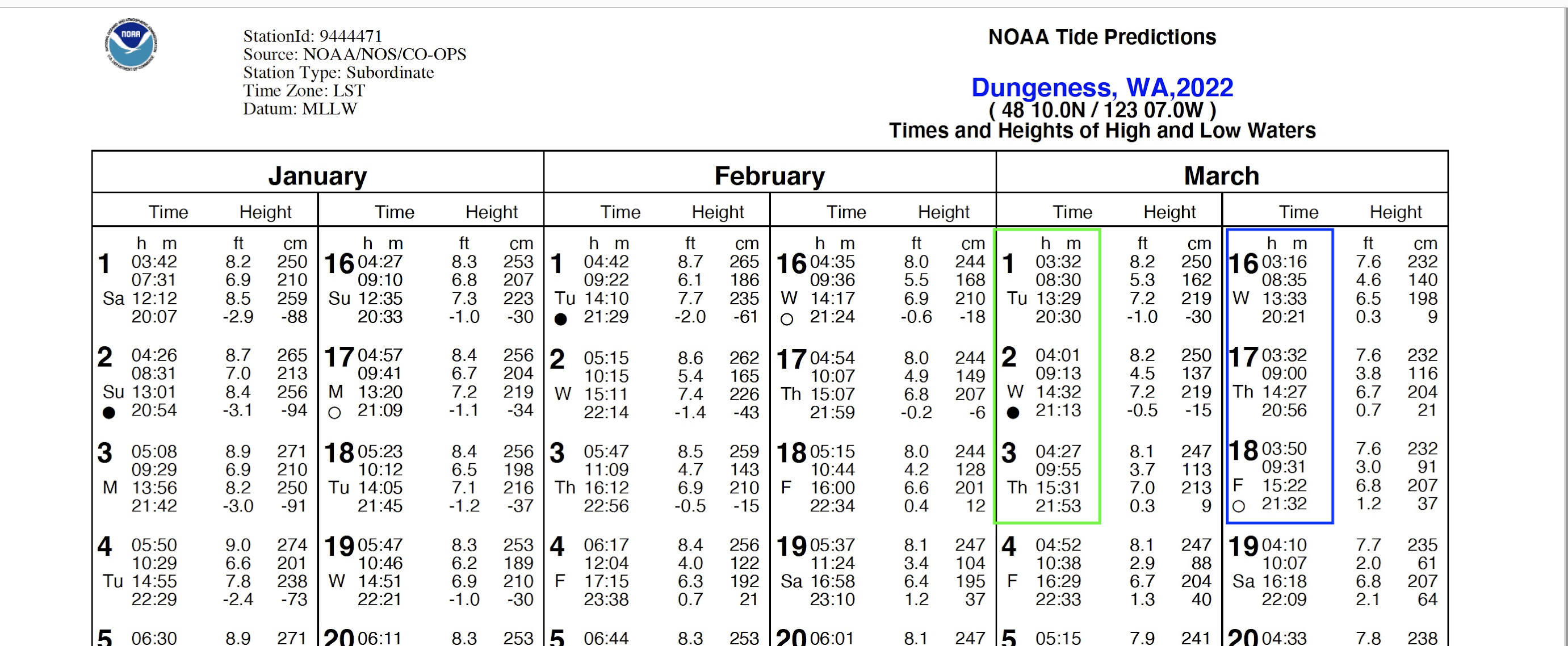
This website provides annual predictions for the present year and two years into the future for every station. These are in convenient letter size PDF format, 2 pages (back-to-back) per year. Somewhat like we will be doing in the future with the new NOAA Custom Charts (NCC), we can make our own custom tide and current tables in minutes.
Chances are third party printers will eventually do as the Canadians do now; they print combined tides and currents tables for local regions, rather than entire coasts or oceans. In short, industry needs for printed versions can be created as called for. Furthermore, we do not necessarily need printed documents.
For vessels on longer voyages, we note that tide and current predictions are not required by the USCG to be in print. They can be in PDF format (or text or html) in your computer, tablet, or phone. You can, for example, download the stations you care about from within your phone and save them in your favorite ebook reader library. They handle PDFs very nicely and keep them organized and easy to access.
That is the guaranteed way to have the right data—download the PDFs from NOAA. But there are many apps that provide this data without doing anything. They are using harmonic constants to compute the predictions. These apps and their harmonic constants are not individually sanctioned by the USCG or NOAA. The USCG requirement is you must be using the latest data that comes from NOAA. This then becomes a bit tricky. None of the free phone apps that I know of actually promise that. Most mariners have taken it on faith that a nav app will generate the right predictions, but sadly we can show that is not always the case.
In the end, if we are going to rely on a nav app for this data, we need to at least spot check a few cases with the official data at NOAA.
Instructions for use of NOAA tide and current tables online
There are instructions at the NOAA site, but since they have so much data there, these steps might be helpful. We start by using their service to find the closest station to where we want the predictions:
1) Go to tidesandcurrents.noaa.gov. Click your state of interest
2) In the top left popup menu click Advanced
3) In Data Type dropdown, select Tide Predictions or Current Predictions
4) Then zoom the map with a mouse roller or the +/- keys bottom right until the stations show up.
5) You will see harmonic (purple) and subordinate (white) stations, but this distinction has no significance at this point. Using the Legend option on the top right you can change the background to an ENC nautical chart.
6) Click your station to get the data, which will be the present (Today's) values. For other dates in the past or future (2yrs) see below.


7) For current stations, there will be data at several depths, so we have to choose the value closest to our draft, which is almost always the one with the shallowest depth. Requesting another date is easier than with tides as dates are listed for all data.
8) For an annual set of predictions for that station, click More Data, then for tides, on the right, click Annual Tide Tables; for currents, click the tab Annual Prediction Tables.
9) For both tides and currents, you have a choice for the times: either GMT (meaning UTC), or LST, which would be the same as the old, printed tables that did not correct for daylight saving time, or you can now choose LST/LDT, which means the times given will correct for daylight saving time when the clocks change, 02 local time on Mar 14 and Nov 7.
The sample above uses local standard time, which does not correct for local daylight time. This is the format that all the old tables had, so we always had to be very careful about that.
Now we have an option to show this data corrected. You will notice below that they are the same up till March 14 and then they show up with an hour added. Historically we had to do that ourselves.

Commercial chart navigation programs such as Coastal Explorer and Time Zero and others have very convenient and versatile tide and current interfaces, and I am sure they update the harmonic constants from NOAA to keep the US data in sync with NOAA.
Popular free navigation programs leave it up to us to be sure we are using the best harmonics for the predictions, which is a bit of a longer story. The USCG requirement, which matches our own obvious goal to have the best possible data, is whatever we use should be traceable to the latest NOAA data.
The easy check on this is just use your electronic solution to get tide and current predictions at a place of interest, then get the same predictions from the NOAA link above and compare them. These checks take just minutes.
Looking ahead, NOAA publishes the harmonic values for each station that programmers can extract and use, but these data are not yet in a form that individual mariners might use to update their own navigation programs. In the future this might change, in which case we could end up with NOAA version dates on our electronic tide and current predictions just as we have on our nautical charts.
No comments:
Post a Comment