This is an outline of a talk given at Captain's Nautical Supply on May 15, 2018 in support of the Coho HoHo program.
Those reading online will need to do some reading between the lines... or better still, get a copy of our book on the subject!
_________________
• These days there is no reason not to have every chart we might ever want stored on our computers, tablets, or even phones.
• Tablets are handy, but we can still do very much more with a computer.
• Generally PCs are still more functional than Macs for navigation and weather... the only exception is LuckGrib.com for Mac, which also has an iOS version for PC users with an iPad. This is the state of the art GRIB source and viewer without parallel, on any platform. Mac or iOS costs $20. (I have no financial ties to this product, but am a strong proponent... if you care about weather, it will change your life!)
• Main reference: Introduction to Electronic Chart Navigation. This is a unique resource with information not found in other sources. Crucial to successful use of ENC.
Main value of electronic chart systems (ECS) over paper charts
• Boat position tracks on the chart, as well as AIS targets
Prior to live GPS tracks on our chart screen (ie ECS), navigators were always finding where the boat was some time ago, since it takes time to plot out the piloting fix during which the boat is moving. A main revolution of ECS is we now know where the boat is on the chart at the moment.
• CPA can be displayed on most ECS (electronic charting systems)
• Depth, obstructions, and other alarms can be set on vector charts.
• Layout routes and compute route table (leg distances, headings, times, names)
• Shows tides and currents. We still have the obligation to check our results periodically.
• Quick range and bearing lines for piloting
• Easy to keep charts up-to-date
• In US waters and other places as well, charts are free whereas paper charts always expensive
• Usually easier to see in various conditions (bright light on the deck is an exception)
• Vector charts have more detail than paper charts
Main value of paper charts over echarts
• They don't require power.
• The view is always the same and cannot be screwed up by wrong device settings, or a mis-click at a crucial time. (Generally tricky situations are best navigated with echarts, with the best paper chart laid out on the chart table.)
• Anyone on the boat can walk up to the chart table and understand what they are seeing; they do not need to turn on a computer or be trained in the use of the ECS.
• As such, a minimum number of paper charts are still required for any voyage. When all traditional paper charts are gone (end of 2024), we will make the paper charts we need from the new NOAA Custom Chart (NCC) program.
• For echarts and paper charts
• Check out the interactive viewer for chart selection
• Check out seamless ENC viewer to see how ENC charts work... i.e., click an object.
• Check out pdf charts... they can be stored in your phone or tablet. They will be discontinued one for one with the paper charts.
• See Fig 1.2-1 [ Figure references are to our electronic charts book above ]

• See also Fig 2.6-2

• ENC require an all new approach to chart reading.
• User controls what is shown on the chart (Base, Standard, Custom).
• User controls the scale of the chart, which is done with RNC as well, but this is more consequential and effective with ENC.
• All objects have an attribute SCAMIN, which is the smallest scale the object will be displayed upon. This is a subtly to be reckoned with. A light with SCAMIN 21999, for example, will show when the display is zoomed to 1:20,000, but will not show if you zoom out to 1:23,000. This feature of ENC can be overridden by user controls in most programs.
• qtVlm and OpenCPN has an excellent presentations of the S-52 format (the official ENC presentation standard)
• Descriptions of many symbols are not printed on the chart, but all are included in object and attribute descriptions accessed by a "cursor pick." Users can usually control the amount of labels to be shown.
• Everything on the chart is an object, which has attributes, one of which is often a category, which in turn has a list of options. See sample in Table 1.7-4. Check links below to see more.

• All objects and attributes are assigned a 6-letter abbreviation i.e., UWTROC. The IHO calls these acronyms, but they are not.
• These descriptions are in our Appendix, but also online at www.caris.com/s-57 Another source online with a different layout is www.s-57.com This one is based in Russia and we are told may not always be up to date, but sometimes its layout makes it easier to find something... also these values do not change very often. These can be called "online ENC object catalogs."
• Where have all the towers gone? There are no towers on ENC. They are now an object LNDMRK, with attribute CATLMK = tower, with maybe a function (FUNCTN) specified, such as radio tower. See other attributes of LNDMRK at one one of the online object catalogs for details.
• Chart names of ENC are different and convey more info that those of RNC. The forthcoming re-schemed ENC include even more information in the chart names. This ENC conversion process is well underway at the moment.
• Regions covered by specific ENC are irregular and do not correspond directly with RNC. See Fig. 1.5-1 and Table 1.5-2. These irregular borders are the main thing being changed in the rescheming program.


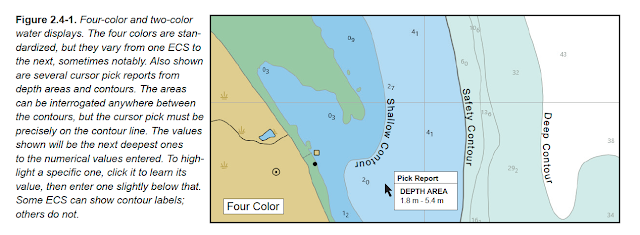
• Safety depth zones can be defined to match the vessel. See Figures 2.4-1a and 2.4-1b.

• More info on the chart. Objects have more specifications, and this will just improve with time, plus they effectively include all Light List data.
• Alarms on obstructions and depths are automatic, whereas if needed on RNC we have to define boundaries.
• Cleaner view of some areas, with options to "over zoom" in productive ways.
• US ENC one of the few that do the height datum contour correctly. Can use it to read MHW. See Figure 2.8-2. The renowned UKHO ENC do not do this properly! Canadian ENC are even worse on this detail, though both are otherwise fine sources of ENC.

• File size for storage and update delivery is much smaller than RNC. (Once activated in your nav program this is less of a factor, because the ENC size gets doubled when creating the necessary SENC files, but even doubled they are notably smaller.)
• Looking ahead, the new S-412 weather overlays planned by the NWS will be so powerful that we will be forced to use ENC just to access that program. See discussion in our new book Modern Marine Weather, 3rd ed.
• As such, a minimum number of paper charts are still required for any voyage. When all traditional paper charts are gone (end of 2024), we will make the paper charts we need from the new NOAA Custom Chart (NCC) program.
Overview of our resource starpath.com/getcharts
• Check out the interactive viewer for chart selection
• Check out seamless ENC viewer to see how ENC charts work... i.e., click an object.
• Check out pdf charts... they can be stored in your phone or tablet. They will be discontinued one for one with the paper charts.
Using ENC (electronic navigational charts)
compared to
RNC (raster navigational charts)
• See Fig 1.2-1 [ Figure references are to our electronic charts book above ]

• See also Fig 2.6-2

• ENC require an all new approach to chart reading.
• User controls what is shown on the chart (Base, Standard, Custom).
• User controls the scale of the chart, which is done with RNC as well, but this is more consequential and effective with ENC.
• All objects have an attribute SCAMIN, which is the smallest scale the object will be displayed upon. This is a subtly to be reckoned with. A light with SCAMIN 21999, for example, will show when the display is zoomed to 1:20,000, but will not show if you zoom out to 1:23,000. This feature of ENC can be overridden by user controls in most programs.
• qtVlm and OpenCPN has an excellent presentations of the S-52 format (the official ENC presentation standard)
• Descriptions of many symbols are not printed on the chart, but all are included in object and attribute descriptions accessed by a "cursor pick." Users can usually control the amount of labels to be shown.
• Everything on the chart is an object, which has attributes, one of which is often a category, which in turn has a list of options. See sample in Table 1.7-4. Check links below to see more.
• All objects and attributes are assigned a 6-letter abbreviation i.e., UWTROC. The IHO calls these acronyms, but they are not.
• These descriptions are in our Appendix, but also online at www.caris.com/s-57 Another source online with a different layout is www.s-57.com This one is based in Russia and we are told may not always be up to date, but sometimes its layout makes it easier to find something... also these values do not change very often. These can be called "online ENC object catalogs."
• Where have all the towers gone? There are no towers on ENC. They are now an object LNDMRK, with attribute CATLMK = tower, with maybe a function (FUNCTN) specified, such as radio tower. See other attributes of LNDMRK at one one of the online object catalogs for details.
• Chart names of ENC are different and convey more info that those of RNC. The forthcoming re-schemed ENC include even more information in the chart names. This ENC conversion process is well underway at the moment.
• Regions covered by specific ENC are irregular and do not correspond directly with RNC. See Fig. 1.5-1 and Table 1.5-2. These irregular borders are the main thing being changed in the rescheming program.


• Safety depth zones can be defined to match the vessel. See Figures 2.4-1a and 2.4-1b.


Special Value of ENC
• More info on the chart. Objects have more specifications, and this will just improve with time, plus they effectively include all Light List data.
• Alarms on obstructions and depths are automatic, whereas if needed on RNC we have to define boundaries.
• Cleaner view of some areas, with options to "over zoom" in productive ways.
• US ENC one of the few that do the height datum contour correctly. Can use it to read MHW. See Figure 2.8-2. The renowned UKHO ENC do not do this properly! Canadian ENC are even worse on this detail, though both are otherwise fine sources of ENC.

• File size for storage and update delivery is much smaller than RNC. (Once activated in your nav program this is less of a factor, because the ENC size gets doubled when creating the necessary SENC files, but even doubled they are notably smaller.)
• Looking ahead, the new S-412 weather overlays planned by the NWS will be so powerful that we will be forced to use ENC just to access that program. See discussion in our new book Modern Marine Weather, 3rd ed.
No comments:
Post a Comment