The parameters that lead to icing are wind speed, air temp, and sea state, which are taken into account in the NWS warnings and forecasts on icing conditions. NWS maps as well as custom ice maps mark boundaries as well as the propensity for ice accretion, including rates. In worst conditions, the ice can build up at remarkably fast rate.
The blue dots mark the solid ice edge. The line of red rectangles marks the boundary of likely icing, with a one line symbol being moderate potential, and two bars being heavy potential.
No incident brings the point home more than the recent NTSB's detailed report on the Capsizing and Sinking of Fishing Vessel Destination, with the loss of 6 lives and 2.5 million dollars of property. Sadly similar to the El Faro case, it was an example of poor training and disregard of clear warnings and forecasts. The full report is an excellent background on the factors involved, with many references. The sketch below shows that the fatal build up took place in essentially one day.
Much of the fundamental research on icing was carried out by Jim Overland of NOAA/PMEL, here in Seattle. What is now called the Overland Index can be used to estimate ice build up. His method, and an excellent article on the whole subject, is in the Mariners Weather Log, a publication of the Voluntary Observing Ship program. See:
The Overland Index (reproduced from the above article) is
The formula can be used to generate graphs for various water temperatures such as
For example, with a water temp of 32.9 F (0.5 C) and air temp of 13 F (-10.5 C) and 20 kts (10.3 m/s) we have PPR = 10.3*[1.75-(-10.5)]/[1+0.3*(0.5-1.75)] = 53.8, which is the line between moderate and heavy, at about 2 cm per hour build up.
Below are expected thresholds, which keeps this in perspective for private vessels venturing into cold climates. A 49-ft yacht, in just 2-ft waves can expect some icing to develop with just 10 kts of wind when the air and water are very cold—then use the Overland Index
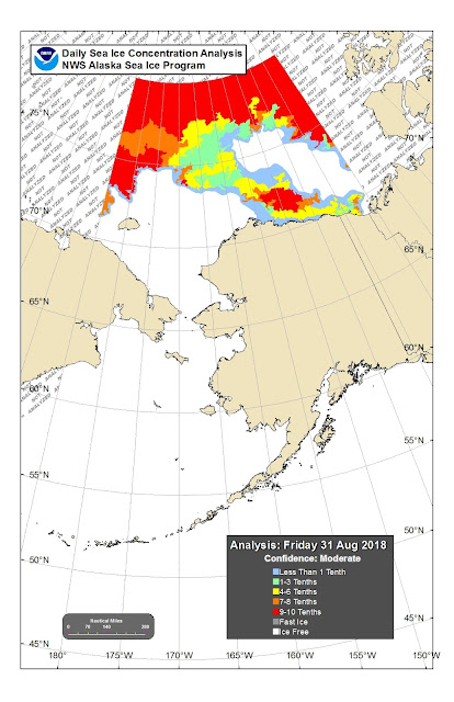
The Anchorage Forecast Office has a special section on forecasting that highlights icing forecasts. Below are the ice limits for today, in one of the regions covered. The regions are very specific on that page.
These ice limits obviously go way south as we approach winter, well down into the Bering Strait and remain fast until late spring... which makes one wonder why there is so much speculation about the importance of a land bridge (Beringa) when it comes to populating North America from Eurasia—much of the year you can just bundle up and walk across. Unless I read the data wrong, there was more ice 20,000 years ago at the proposed time of this migration than now. It seems the more compelling question is why don't we build the bridge now!
Environment Canada has excellent ice resources and forecasting. The Great Lakes are also covered with extensive resources at NOAA's Great Lakes Environmental Research Laboratory, Ice Coverage Section. This is also the main site for all Great Lakes weather.
Here are a few more reminders on what severe icing looks like.
This winter we will come back to this topic when we have more live data of actual icing conditions to show how it is forecasted, and how we can anticipate the forecasts based on the Overland Index.
Also on the list is to add a section on Ice Navigation in general, in or near pack ice, even when there is no threat of icing on deck. There are many excellent public resources. For now we just needed this article for an update to our online marine weather course materials.


No comments:
Post a Comment