One great virtue of electronic charts is their ability to be updated quickly by both NOAA's Office of Coast Survey (OCS), who makes the charts, and then the mariners who use them on the water. Electronic Navigational Charts (ENC) are updated weekly by OCS. All type-approved ECDIS (electronic chart display and information system) software as well as many ECS (electronic chart system) used by recreational mariners such as OpenCPN, Coastal Explorer, and Time Zero products offer an automated chart update service built right into the navigation software.
You can configure the nav programs to check for new charts every time you start the program, or you can update manually. Then if you are online at the time, the program logs into the right NOAA web page, checks for latest charts, and downloads new ones. NOAA provides the needed application programing interface (API) for programmers to use for this.
An important caveat to this process is: for this to work, you must have loaded the charts in the first place using the program's own chart loading function. Most nav programs with the auto-update option have two ways to initially load a chart: select it from a list of charts they provide and then the program gets the charts for you, or it lets you load charts manually by simply telling the program where charts are located on your computer. Loading charts manually can bypass the auto-update functionality. It is important to understand how your own ECS handles these updates. Using OpenCPN, for example, this means using the Chart Downloader plugin for all charts you want to automate, and then store all such charts in the same folder selected in that function.
To illustrate the power of modern chart updating options, we take a look at how mariner's can take part in the process with what is effectively "crowd sourced" chart updating. We will look over the submission process for a user reported chart correction, and then follow through on it showing up in subsequent charts. We posted an earlier article on this process featuring a UKHO app designed for this. The US counterpart described there has since changed to what we show here, but the UKHO app is still available, and as far as we know could still be used to report comments on US charts, although the procedure shown here is the most direct.
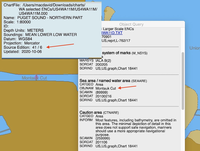
What led us to return to this topic is we ran across a prominent naming error on ENC number US4WA11M (Puget Sound, Northern Part) that mis-labeled Montlake Cut at the west end of the Ship Canal that leads from the Puget Sound via the Ballard Locks into Lake Washington. On that chart it was called Montauk Cut—a famous maritime name for sure, but from NYC, not Seattle. Chart US4WA11M is scale 1:80,000, which is within the scale band 5 that spans scales of 1:50,000 to 1:150,000.
Here is the location we discuss within Puget Sound, followed by the object of interest shown on a chart.
Montlake Cut can also be seen on scale band 5 chart US5WA13M, which is 1:25,000. If we zoom in to that scale we see that the Cut and Bridge are labeled correctly on that chart, so the only issue is US4WA11M.
From: NOAA Coast Survey Customer Response for Ticket #148408
3:35 PM Monday, Nov 2, 2020
Thank you for your inquiry into NOS products. You are right, the name of the waterway was incorrect on US4WA11. It has been revised in our database from Montauk Cut to Montlake Cut. An update for US4WA11 (Edition 41, Update 7) should be available for download within a week. Again, I'd like to extend my thanks to you for pointing out this error, so that it could be corrected.
Sincerely,
[name given]
Original Message:
-----------------------------------
"Good day, I would like to point out that on US4WA11 the Montlake Cut is misprinted as "Montauk Cut." This does not show up on US5WA13, as noted in the attachments. Please let me know that you have received this, and if you can, please give me an estimate of when we might expect this to be corrected. Thanks very much. David Burch / Starpath School of Navigation / Seattle"
I am not sure when the actual update was made, but three days later on thursday we checked by doing a chart update for US4WA11M, and found the following:
So we see that it was indeed already fixed! The new one is edition 41 /7. We can go the charts list to check when it was actually made (see link at www.starpath.com/getcharts):


1 comment:
Your post prompted me to take another shot at getting multiple errors corrected regarding the lights in the Des Moines (WA) Marina. Here's one example: "Des Moines Marina Lighted Buoy 1 is shown as having a 2.5s period. The actual period is 4.0s, with a sequence of 00.5+(03.5). This is also incorrect on the raster chart." Unfortunately, the response I got was that this was the purview of the Coast Guard and that they would forward it to the 13th Coast Guard District.
I say "unfortunately", because I'd sent this to the Coast Guard several years ago. Their response was that the period changes with visibility, implying that what's charted is some kind of average. Of course that's incorrect.
Post a Comment