Monday, September 20, 2021

How to Activate a Color Filter on iPhones for Night Vision

We have three nav apps for iOS (StarPilot and Marine Barograph) that would likely be used at night at some point, so here is a way to help protect night vision when using your iPhone or iPad.

In Settings choose Accessibility


Scroll to bottom to Accessibility Shortcut 


Note at the top it gives specific phone-dependent instructions for engaging the shortcuts.


Put a check on Color Filters


Go back to Accessibility and go to  Display & Text Size  (near the top)


From Display and text size, click Color Filters, and turn it on at the top, Check mark Color Tint.


Slide HUE all the way right to get Red, then choose INTENSITY level with slider above that you want—it will have to be pretty far right to be effective.


Done. Can close Settings.


Then you can turn this on and off with a triple click of the side button or home button on your phone, depending on model.


Note if you have other Accessibility shortcuts checked, you choose between them with the triple click.

Wednesday, September 8, 2021

Landmarks on ENC: The Nuts and Bolts

We have several articles on the role of objects and attributes as used in electronic navigational charts (ENC). Background articles are listed at the end here. In each of these, when it came to the nuts and bolts of this topic, we had to punt, so everyone would not fall asleep. Here is where such a punt might land, namely we take a look at one ENC object, Landmarks, and the primary attributes that ENC include or might include. The object definition is:

Landmark, A prominent object at a fixed location which can be used in determining a location or a direction (adapted from IHO Dictionary, S-32, 5th Edition, 2643).

This object has many attributes because it has such a broad definition. We list here just the primary ones. Among those not listed are: its height (HEIGHT), which is above MHW; we could measure that with a sextant (top of the object to the waterline below it) to get distance off. This is not to be confused with its elevation (ELEVAT) which is above MSL, nor with its actual height above the ground, called its vertical length (VERLEN).  The attributes marked * are the only actual required ones, but landmarks typically include Function as well. If more than one color is specified, then the color pattern must also be given, which is indicated by the # 

A radio tower would be a landmark with category = tower (17) and function = radio (31); if visually conspicuous, its symbol would be a black outline, else it would be brown.  The US only plots a few of the non-conspicuous landmarks, but other nations do a lot more in theirs.

Landmark symbols on an ENC

The main takeaway here is the ENC can include a lot more information than the corresponding paper chart does, although not all of the known information is encoded at present. This is where mariners can help by reporting new or outdated information to NOAA. The charts are updated weekly.

Below are the options are for the primary attributes of object Landmark. 

Object Attributes
Landmark *Category, *Conspicuous visually, Function, Color, #Color pattern, Status, Condition, Conspicuous radar
LNDMRK CATLAM, CONVIS, FUNCTN, COLOUR, COLPAT, STATUS, CONDTN, CONRAD
 
CATLAM Category of the landmark
1 cairn: a mound of stones, usually conical or pyramidal, raised as a landmark or to designate a point of importance in surveying. (IHO Dictionary, S-32, 5th Edition, 601)
2 cemetery: an area of land for burying the dead.
3 chimney: a vertical structure containing a passage or flue for discharging smoke and gases. (Digital Geographic Information Standard - DIGEST)
4 dish aerial: a parabolic aerial for the receipt and transmission of high frequency radio signals. (IHO Dictionary, S-32, 5th Edition, 1400)
5 flagstaff (flagpole): a staff or pole on which flags are raised. (Digital Geographic Information Standard -DIGEST 1.28)
6 flare stack: a tall structure used for burning-off waste oil or gas. (IHO Dictionary, S-32, 5th Edition, 1836). Normally showing a flame and located at refineries (IHO Chart specifications, S-4).
7 mast: a straight vertical piece of timber or a hollow cylinder. (adapted from Digital Geographic Information Standard - DIGEST)
8 wind sock: a tapered fabric sleeve mounted so as to catch and swing with the wind, thus indicating the wind direction. (Navigation dictionary, US National Oceanic and Atmospheric Administration - NOAA, 1969)
9 monument: a structure erected or maintained as a memorial to a person or event. (Digital Geographic Information Standard - DIGEST)
10 column (pillar): a cylindrical or slightly tapering body of considerably greater length than diameter erected vertically. (Oxford English Dictionary)
11 memorial plaque: a slab of metal, usually ornamented, erected as a memorial to a person or event.
12 obelisk: a tapering shaft usually of stone or concrete, square or rectangular in section, with a pyramidal apex. (Adapted from Oxford English Dictionary)
13 statue: a representation of a human, animal or fantasy figure in marble, bronze, etc.
14 cross: a monument, or other structure in form of a cross. (Funk & Wagnalls Dictionary)
15 dome: a landmark comprising a hemispherical or spheroidal shaped structure (adapted from the Macquarie Dictionary).
16 radar scanner: a device used for directing a radar beam through a search pattern (adapted from Navigation Dictionary, US National Oceanic and Atmospheric Administration -NOAA, 1969)
17 tower: a relatively tall structure which may be used for observation, support, storage or communication etc. (Digital Geographic Information Working Group -DGIWG, Oct. 1987)
18 windmill: a wind driven system of vanes attached to a tower like structure (excluding wind-generated power plants). (Digital Geographic Information Standard - DIGEST)
19 windmotor: a modern structure for the use of windpower. (IHO Chart Specifications, S-4)
20 spire/minaret: a tall conical or pyramid-shaped structure often built on the roof or tower of a building, especially a church or mosque. (adapted from The New Shorter Oxford English Dictionary, 1993)
21 large rock or boulder on land: an isolated rocky formation or a single large stone (IHO Dictionary, S-32, 5th Edition 4415)
22 rock pinnacle: high tower or spire-shaped pillar of rock, alone or cresting a summit (adapted from IHO Dictionary, S-32, 5th Edition 3852)
 
CONVIS Conspicuous, visually
1 visually conspicuous: term applied to an object either natural or artificial which is distinctly and notably visible from seaward. (IHO Dictionary, S-32, 5th Edition, 984)
2 not visually conspicuous: an object which is visible from seaward, but is not conspicuous.
 
FUNCTN Function of the landmark
1 No function / service of major interest:
2 harbour-master's office: the office of the local official who has charge of mooring and berthing of vessels, collecting harbour fees, etc. (adapted from IHO Dictionary, S-32, 5th Edition, 2191)
3 customs office: an office which is charged with enforcing customs regulations.
4 health office: the office which is charged with the administration of health laws and sanitary inspections. (adapted from The New Shorter Oxford English Dictionary, 1993)
5 hospital: an institution or establishment providing medical or surgical treatment for the ill or wounded. (The New Shorter Oxford English Dictionary, 1993)
6 post office: the public department, agency or organisation responsible primarily for the collection, transmission and distribution of mail. (The New Shorter Oxford English Dictionary, 1993)
7 hotel: an establishment, especially of a comfortable or luxurious kind, where paying visitors are provided with accommodation, meals and other services. (The New Shorter Oxford English Dictionary, 1993)
8 railway station: a building with platforms where trains arrive, load, discharge and depart. (The New Shorter Oxford English Dictionary, 1993)
9 police station: the office of the local police force.
10 water-police station: the headquarters of a local water-police force.
11 pilot office: the office or headquarters of pilots; the place where the services of a pilot may be obtained. (IHO Dictionary, S-32, 5th Edition, 3845)
12 pilot lookout: a distinctive structure on shore from which personnel keep watch upon events at sea or along the coast. (IHO Dictionary, S-32, 5th Edition, 2917)
13 bank office: an office for custody, deposit, loan, exchange or issue of money. (adapted from The New Shorter Oxford English Dictionary, 1993)
14 headquarters for district control: the quarters of an executive officer (director, manager, etc.) with responsibility for an administrative area.
15 transit shed/warehouse: a building or part of a building for storage of wares or goods. (adapted from The New Shorter Oxford English Dictionary, 1993)
16 factory: a building or buildings with equipment for manufacturing; a workshop. (The New Shorter Oxford English Dictionary, 1993)
17 power station: a stationary plant containing apparatus for large scale conversion of some form of energy (such as hydraulic, steam, chemical or nuclear energy) into electrical energy. (McGraw-Hill Dictionary of Scientific and Technical Terms, 3rd Edition, 1984)
18 administrative: a building for the management of affairs. (adapted from The New Shorter Oxford English Dictionary, 1993)
19 educational facility: a building concerned with education (eg. school, college, university, etc.)
20 church: a building for public Christian worship. (The New Shorter Oxford English Dictionary, 1993)
21 chapel: a place for Christian worship other than a parish, cathedral or church, especially one attached to a private house or institution. (The New Shorter Oxford English Dictionary, 1993)
22 temple: a building for public Jewish worship. (adapted from The New Shorter Oxford English Dictionary, 1993)
23 pagoda: a Hindu or Buddhist temple or sacred building. (The New Shorter Oxford English Dictionary, 1993)
24 shinto shrine: a building for public Shinto worship. (adapted from The New Shorter Oxford English Dictionary, 1993)
25 buddhist temple: see pagoda.
26 mosque: a Muslim place of worship. (The New Shorter Oxford English Dictionary, 1993)
27 marabout: a shrine marking the burial place of a Muslim holy man. (The New Shorter Oxford English Dictionary, 1993)
28 lookout: keeping a watch upon events at sea or along the coast. (adapted from IHO Dictionary, S-32,5th Edition,2917)
29 communication: transmitting and/or receiving electronic communication signals. (adapted from Digital Geographic Information Standard - DIGEST)
30 television: broadcast of television signals.
31 radio: broadcast of radio signals.
32 radar: a method, system or technique of using beamed, reflected, and timed radio waves for detecting, locating, or tracking objects, and for measuring altitudes. (IHO Dictionary, S-32, 5th Edition,4158)
33 light support: supporting a light
34 microwave: broadcasting and receiving signals using microwaves.
35 cooling: dissipating heat.
36 observation: a place from which the surroundings can be observed but at which a watch is not habitually maintained. (adapted from IHO Dictionary, S-32, 5th Edition,2917)
37 time ball: a visual time signal in form of a ball
38 clock: visual time signal. (adapted from S-32, 5th Edition, 5536)
39 control: used to control the flow of air, rail, or marine traffic. (Digital Geographic Information Standard - DIGEST)
40 airship mooring: a facility to secure an airship. (adapted from Digital Geographic Information Standard - DIGEST)
41 stadium: a large usually unroofed building with tiers of seats for spectators
42 bus station: a location at which buses arrive and from which they depart.
 
COLOUR Color of landmark
1 white
2 black
3 red
4 green
5 blue
6 yellow
7 grey
8 brown
9 amber
10 violet
11 orange
12 magenta
13 pink
 
COLPAT Color pattern
1 horizontal stripes: straight bands or stripes of differing colours painted horizontally.
2 vertical stripes: straight bands or stripes of differing colours painted vertically.
3 diagonal stripes: straight bands or stripes of differing colours painted diagonally (ie not horizontally or vertically).
4 squared: often referred to as checker plate, where alternate colours are used to create squares similar to a chess or draught board. The pattern may be straight or diagonal.
5 stripes (direction unknown): straight bands or stripes of differing colours painted in an unknown direction.
6 border stripe: a band or stripe of colour which is displayed around the outer edge of the object, which may also form a border to an inner pattern or plain colour.
 
CONDTN Condition of the landmark
1 under construction: a structure that is in the process of being built.
2 ruined: a structure in a decayed or deteriorated condition resulting from neglect or disuse, or a damaged structure in need of repair. (IHO Dictionary, S-32, 5th Edition, 4456)
3 under reclamation: an area of the sea that is being reclaimed as land, usually by the dumping of earth and other material.
4 wingless: a windmill or windmotor from which the turbine blades are missing.
5 planned construction: an area where a future construction is planned.
 
STATUS Status of landmark
1 permanent: intended to last or function indefinitely. (The Concise Oxford Dictionary, 7th Edition)
2 occasional: acting on special occasions; happening irregularly. (The Concise Oxford Dictionary, 7th Edition)
3 recommended: presented as worthy of confidence, acceptance, use, etc. (The Macquarie Dictionary, 1988)
4 not in use: no longer used for the purpose intended; disused.
5 periodic/intermittent: recurring at intervals. (The Concise Oxford Dictionary, 7th Edition)
6 reserved: set apart for some specific use. (adapted from The Concise Oxford Dictionary, 7th Edition)
7 temporary: meant to last only for a time. (The Concise Oxford Dictionary)
8 private: not in public ownership or operation.
9 mandatory: compulsory; enforced. (The Concise Oxford Dictionary, 7th Edition)
10
11 extinguished: no longer lit illuminated: lit by floodlights, strip lights, etc.
12 illuminated: lit by floodlights, strip lights, etc.
13 historic: famous in history; of historical interest. (The Concise Oxford Dictionary, 7th Edition)
14 public: belonging to, available to, used or shared by, the community as a whole and not restricted to private use. (adapted from The New Shorter Oxford English Dictionary, 1993)
15 synchronized: occur at a time, coincide in point of time, be contemporary or simultaneous. (The New Shorter Oxford English Dictionary, 1993)
16 watched: looked at or observed over a period of time especially so as to be aware of any movement or change. (adapted from The New Shorter Oxford English Dictionary, 1993)
17 un-watched: usually automatic in operation, without any permanently-stationed personnel to superintend it. (adapted from IHO Dictionary, S-32, 5th Edition, 2814)
18 existence doubtful: an object that has been reported but has not been definitely determined to exist.
 
CONRAD Conspicuous by radar
1 radar conspicuous: an object which returns a strong radar echo. (IHO Dictionary, S-32, 5th Edition, 4142)
2 not radar conspicuous: an object which does not return a particularly strong radar echo.
3 radar conspicuous (has radar reflector): an object which returns a strong radar echo, having a radar reflector.

Background articles include:

Monday, September 6, 2021

Where Have All the Towers Gone? — Getting Into ENC Terminology

As you may know, NOAA is well into the process of sunsetting all paper charts, which is their way of saying they are replacing them with electronic navigational charts (ENC) and the new NOAA Custom Charts (NCC), a user designed and printed hybrid of the new and the old. This process will be complete (meaning no traditional paper charts left at all) by the end of 2024.

The ENC are indeed better than the traditional charts we are used to, but they are now all electronic products—even the new ones (NCC) that we print ourselves are based on the digital ENC. As such, they are effectively databases of charted objects, along with multiple attributes for each object. Both objects and attributes have 6-letter abbreviations.  


One type of object, for example, would be a Lateral buoy (BOYLAT). This object can have multiple attributes. It must have an attribute Buoy shape (BOYSHP), which In turn will have one of eight different values, including the common ones, 1=conical, 2=can, 3=spherical, etc. It must also have attribute Category of lateral mark (CATLAM), which can be 1=port side, 2=starboard side, 3=preferred to starboard, or 4= preferred to port.


It must also have attribute Color (COLOUR), which can have thirteen values, and it must have an attribute Color pattern (COLPAT) which has 6 possible values, starting with 1=horizontal stripes, 2=vertical stripes, etc.


Besides these required attributes, the object BOYLAT could have an attribute Object name (OBJNAM), which is common, and it could have its height specified as its Vertical length (VERLEN), but this is rare. And it has an attribute Conspicuous by radar (CONRAD) with values 1=radar conspicuous, 2=not radar conspicuous, 3=has radar reflector…  and other attributes, such as its Status (STATUS), which has eighteen values including 1=permanent, 7=temporary, 8=private, and so on. Plus half a dozen more attributes, including Scale minimum (SCAMIN), which is the minimum displayed chart scale required for this object to show up on the display—a unique property of ENC, but this one can be overridden by user controls.


We see that this new chart object structure is all very specific, but we note that a light or bell or racon is somehow no longer an attribute of the buoy. Before we had lighted buoys; now we have lights and we have buoys, and we have fog signals, and we have racons. These are now all separate objects, and each of these objects will have its own set of attributes. The list of attributes for a Light (object LIGHTS) is long and complex.


When an experienced navigator looks over the list of some 400 charted objects, two things stand out immediately: there is no object called "Tower," and even more surprising, there is no charted object called "Rock." This is one of the moments when we question whether we are going to like this new chart system or not! On the other hand, this is not at all a problem for someone brand new to navigation, who has not worked with paper charts for years. They do not have the muscle memory of the role these objects played in their lives for so long.


But after a few deep breaths, we realize that if we are to organize charted objects into logical categories, we can think of a tower as a type of landmark, which is indeed how this works. We have the chart object Landmark (LNDMRK), which has an attribute Category of landmark (CATLMK) that takes on one of twenty options, such as 3=chimney, 9=monument, or 17=tower. We can also have cairn, mast, statue, windmill, and so on. 


Paper chart (RNC) on the left. ENC on the right do not have labels for landmarks unless it has an Object Name (OBJNAM), but they do have different symbols for different values of CATLMK and FUNCTN. These are views from OpenCPNs split screen option. The inserts are the pick reports from the ENC chart on the right. In passing, note that RNC sector lights mark where the light is obscured, but ENC marks the area where they can be seen.


This is certainly a manageable structure to Iive with, but we have to deep breathe again when we learn that landmark objects will most likely not have a label on the chart as we are used to in RNC, so we have to click it to read it. This is another part of what we have to learn about the use of electronic navigational charts. The various landmark symbols are shown below from the NOAA Chart No, 1.


The statement top left that non conspicuous landmarks are not shown on NOAA ENC does not seem to be true, but i will have to look more into this. Some do exist, we have practice quizzes using them, but maybe the ones we found are chart errors? There are certainly a lot in Europe on official ENC there.


From this we begin to see benefits over paper charts as well. We learn, for example, that landmarks have another attribute called Visually conspicuous (CONVIS), with values 1=yes and 2=no. Then it turns out that the symbols are subtly different for conspicuous landmarks—they have black outlines, whereas not conspicuous have brown outlines—look out for that one on our quizzes! We do not know if a landmark is conspicuous or not by looking at a tower symbol on a paper chart, just as we likely do not know its color, color pattern, height above the ground, radar observability, and more, which we can learn from an ENC if these data happen to be encoded for that specific landmark. In short, things are different, but once we adapt to that, we see things are better... or certainly potentially better.


Rocks are another story, which I leave to another note. The object is Underwater/awash rock (UWTROC). Unlike paper charts with three rock symbols, all rocks on ENC have the same symbol, which we distinguish with a right click on the asterisk symbol to read the attributes. Also there is a new definition of "awash," which merits its own discussion.


The structure and use of ENC is the main topic of our book on electronic chart navigation.


Wednesday, August 25, 2021

MHW on ENC

The value of mean high water (MWH) at a specific location on a chart can be a crucial number in marine navigation. We need it to figure how far we can see a light at night, and we need it to figure what a bridge clearance will be. It is also needed to know whether certain rocks will be visible or not at various stages of the tide. These are all basic safety considerations we face in routine navigation.

MHW plays these roles because MHW is the height datum used on US nautical charts, which is the zero point for light heights and bridge clearances. This is not the same as the elevation datum used for elevation contours and spot elevations shown on charts. The elevation datum is mean sea level (MSL), which for most  practical purposes can be considered equal to the mean tide level, halfway between MLW and MHW.

Strangely enough, the important values of MHW were not listed in the standard NOAA Tide Tables (which ceased publication in 2021), but they are listed on every printed nautical chart and their RNC counterparts. The data appear in a table called Tidal Information. There are generally several values listed for points across the chart.


As we transition into all electronic navigational charts (ENC), however, we notice the MHW data are not so readily apparent. In fact, we get MHW from an ENC in a rather subtle manner. Namely the green foreshore shown on a chart is a specified depth area (DEPARE) object whose two bounding contours are the sounding datum (tide = 0) on the water side, and the height datum (tide = MHW) on the land side. The latter is effectively the drying height of the land at tide = 0, thus it is presented as a negative contour height equal to MHW.  See Introduction to Electronic Chart Navigation, for details of this process.


That is the way it works, and it is certainly no harder, if not easier, to learn MHW from an ENC than it is from an RNC.

The nuance to this process comes about because the ENC uses only one value of height datum (MHW) for the full range of the chart. This is not an issue for larger scale charts covering smaller regions as then the MHW does not vary much, but on small scale charts, even just at 1:80,000 we can have MWH from one part to another vary by as much as 3 feet. When this occurs, NOAA chooses just one value to represent all values on the chart, and that one value is, according to NOAA, chosen "with safety in mind,"  which I emphasize as that is the topic at hand.
_________

Here is an example from the same region referred to in the Tidal Information table above that was captured from an RNC near Port Townsend, WA. First we look at two ENC chart scales, then the MHW on each.


We see that on a large scale chart, the ENC values change very little over the chart and the single value selected is a good representation of the actual values that we can read in the RNC table above. The Oak Bay value is on the south side of the Canal; the Port Townsend value is on the north side of the Canal.


When we look at this same area on a much smaller chart scale, we now see that the ENC has chosen to use 10.5 ft to represent MHW on all areas on this chart, which does indeed span a much wider range of MHW values.


The question at hand is what does "safety in mind" mean in this choice.  If we have a range of MHW values, would the safest choice be the lowest of all of them, or the highest of all of them, or the average of the known values?  

Bridge Clearance.
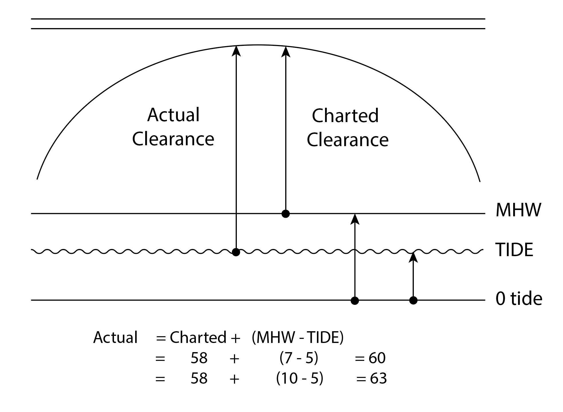
Bridge clearance is maybe the most direct example. As I approach a bridge to pass under and my mast is right near the max that might get through, I know that I count on favorable tide to help me, so I have to reckon the clearance I have.  The charted bridge clearance is 58 ft, which means that when the tide height equals MHW then the distance from water to bridge is 58 ft. When the tide is lower than MHW I have more clearance.

Actual clearance = charted clearance + (MHW - Tide).  When the Tide is exactly MHW,  then I get the charted clearance,  and when the Tide is lower than MHW I get extra clearance, but if the Tide is higher than MHW there is less actual clearance than charted.  With a MHW of 8 ft and a Tide of 3 ft, I would expect a clearance of 58 + 8 - 3 = 63 ft. 

If this computation is to be wrong because the MHW value is wrong, most would agree you would want the clearance to err in the direction of predicting too little clearance, not too much clearance. If it erred being too big, I might try to go though and not make it. If the err makes it too low, I would not try…..or at least I would sneak up on it dead slow, hoping the tide itself was wrong and might sneak under. So with regard to bridge clearances, if my MHW is to be wrong, it is safest to have it be too small, meaning if we have a range of them over a specific ENC, but we can only choose one to use, the safest would be to use the smallest for all parts of the chart.

Here is same example with slightly different values, showing higher MHW leads to potentially misleading higher clearance:


Geographic range of lights.
In clear weather, the visible range of a light is the smaller of the charted nominal range of the light and its geographic range in nmi, which is 1.17 x SQRT (Height of the Light in feet) plus a fixed term based on your height of eye.  The Height of the Light is given on the chart or in the Light List. These tabulated heights are all relative to MHW, which is the height datum of the charts. Thus a light with tabulated height of 20 ft would be that high above the water when the tide equals MHW. If the tide is less than MHW then the light is higher above the same water we are floating in, so we can see it from farther away. 

Similar to the bridge clearance, actual Light height above the water = Tabulated height + (MHW - Tide). So then what is "safest" or most conservative if the MHW is to be off a bit? Do we want it too big, which would make the light higher than correct and thus visible from slightly farther than the truth, or do we want the visible range slightly under estimated with a low end MHW?  In other words, if the actual visible range to a light is 8 nmi, am I safer thinking it is 7 nmi or 9 nmi if it has to be one or the other.

My thought would be that it is safer to have the smaller range when planning an approach at night, and then when I see it earlier I know what to do, whereas if I think I should see it 9 nmi and do not, then I am not sure what is wrong with my navigation. So again in this case, the "safer" way to error on MHW is to take the lower limit.

Visibility of rocks.
On paper charts we have 3 kinds of rock symbols: a "plus-sign rock," which is a rock that is underwater for all tide heights greater than 0; an "asterisk rock,"  which is one that covers and uncovers when the tide is in the range of 0 to MHW (the height datum); and a "plus sign with 4 dots rock" that is awash when the tide is exactly or very near 0.  

ENC has one rock object called UWTROC (Underwater/awash rock), which has an attribute WATLEV (Water level effect), which in turn can have values:

1. partly submerged at high water: partially covered and partially dry at high water.

2. always dry: not covered at high water under average meteorological conditions. [ This is an islet, not a rock. ]

3. always under water/submerged: remains covered by water at all times under average meteorological conditions. [ This is analogous to plus-sign rock. ]

4. covers and uncovers: expression intended to indicate an area of a reef or other projection from the bottom of a body of water which periodically extends above and is submerged below the surface. Also referred to as dries or uncovers. (IHO Dictionary, S-32, 5th Edition, 1111). [ This is analogous to the asterisk rock. ]

5. awash: flush with, or washed by the waves at low water under average meteorological conditions. (adapted from IHO Dictionary, S-32, 5th Edition, 308) [ This is the plus-sign with 4 dots rock. ]

6. subject to inundation or flooding: an area periodically covered by flood water, excluding tidal waters. (Digital Geographic Information Standard - DIGEST 1.2)

7. floating: Resting or moving on the surface of a liquid without sinking (Concise oxford Dictionary)

Here we confront several distinctions between RNC rocks and ENC rocks. First a simple terminology distinction. Paper charts refer to rocks awash as those that cover and uncover as the tide changes from the sounding datum (0 tide) to the height datum (MHW). We can confirm that in the IHO document S-4, where this K11 rock is listed as B-421.2.  This rock has a symbol of a simple asterisk on both RNC and ENC. On ENC it has a WATLEV = 4. 


Here is the Bowditch definition, which is consistent with IHO S-4:

rock awash. A rock that becomes exposed, or nearly so, between chart sounding datum and mean high water.

In contrast, S-57 defines "rock awash" as one that is awash at or near the sounding datum, tide height = 0.  The ENC uses an asterisk for this rock as well, but assigns a WATLEV = 4.  Note that we must know the ENC definition of "awash" when reading this cursor pick.

The other distinction, which has effect on the present discussion, is the S-57 ENC definition of WATLEV 4, which is covers and uncovers—without any reference at all to the height datum, MHW. The quick conclusion from that is, the ENC choice of MHW therefore cannot have any influence on rock navigation, safe or unsafe, be it too high or too low. We could end it there, but for at least four more years we will navigate with both ENC and RNC, so we should still have a look at the consequences of an ENC error in MHW. 

Right now if we have a rock that dries at 6 ft, with an actual MHW of 6 ft in that area, then this rock would be awash at tide = 6 ft, and for any tide height lower than this we would expect to see that rock.  If  the ENC reported MHW were 4 ft, then we would expect this asterisk symbol rock to be underwater or just at the surface at tide = 4 ft, but in fact when we got there it would be 2 ft above the surface. On the other hand, if the ENC reported the MHW at 8 ft, then we would expect to see this rock for any tide height less than 8 ft, but if we got there at tide 7 ft we would not see the rock.  

In summary, if the above arguments are correct, then it seems that given a range of MHW values from which just one must be selected to encode into an ENC, then the "safest" value would be to choose the lowest one on the chart.

It seems to me that in at least some ENC this is not the guideline being used; it seems the higher end of the range is chosen.  After some effort, i am not able to learn the motivation of the policy in use, so we will stand by on this one.  In the end is will be a moot point, because all ENC are being reschemed and this will lead to charts over smaller areas where this is not a factor.

Note too that with the discontinuation of the Tide and Current Tables we now rely on direct access to NOAA data online and each of the stations includes a link to datums that have the MHW for that location, so we end up with as good or better data than we had.  In fact, it is actually better data, because the values listed on the paper charts and RNC are not being updated, anticipating replacement with the ENC, whereas the NOAA data online are up to date.
___________

In passing, if you might be working with an old set of NOAA Tide Tables, which  do not include MHW, there are two other parameters given for each station from which you can compute MHW.

Mean Range = MR = MHW - MLW

Mean Tide = MT = (MHW + MLW)/2

Thus we can rearrange these terms to solve for MHW = MT + MR/2

In Port Townsend, for example, MR = 5.34 and MT = 5.17, so MHW = 5.17 + 5.34/2 = 7.84